
For six weeks in the summer of 2016 scientists from the United States and the Republic of Korea intensively studied air pollution over the Korean peninsula. Their mission: to diagnose the complex causes of the country’s poor air quality and in so doing lay the groundwork for next-generation pollution monitoring from space that both nations plan to launch in the next few years.
News
Hunting for Lightning: A Day at the GOES-16 Post-Launch Field Campaign

A team of instrument scientists, meteorologists, and specialized pilots have used a high-altitude plane, ground-based sensors, and satellites to collect and compare measurements from across the United States to calibrate and validate the earth viewing instruments on NOAA’s GOES-16 satellite.
Students to Study Earth from Three NASA Flying Laboratories

This summer 32 undergraduate students are participating in an eight-week NASA airborne science field campaign designed to immerse them in the agency's Earth science research.
NASA Aids Study of Lake Michigan High-Ozone Events

NASA researchers are conducting science flights along the Wisconsin-Illinois Lake Michigan shoreline to help better understand the formation and transport of ozone, a potent air pollutant in the region.
Smoke from Wildfires Can Have Lasting Climate Impact

New research using data collected during NASA airborne science campaigns shows how smoke from wildfires worldwide could impact the atmosphere and climate much more than previously thought.
NASA's CPEX Tackles a Weather Fundamental

A NASA-funded field campaign underway in Florida has a real shot at improving meteorologists' ability to answer some of the most fundamental questions about weather: Where will it rain? When? How much?
NASA’s Arctic Ecosystem Science Flights Begin

A NASA-led effort to advance our ability to monitor changing Arctic and boreal ecosystems has started its second season, with the first aircraft taking flight over Alaska and northwest Canada this month.
NASA Polar Ice Survey Flights Conclude
NASA’s annual survey of changes in Arctic ice cover greatly expanded its reach this year in a series of flights that wrapped up on May 12. It was the most ambitious spring campaign in the region for NASA’s Operation IceBridge, an airborne mission to monitor ice changes at Earth’s poles, which also included a rapid-response flight over a new crack in Petermann Glacier, one of the largest and fastest-changing glaciers in Greenland.
Alaska Tundra Source of Early-Winter Carbon Emissions

Three years of observations from NASA’s Carbon in Arctic Reservoirs Vulnerability Experiment (CARVE) airborne mission were used in a new study that shows warmer temperatures and thawing soils may be driving an increase in carbon dioxide emissions from Alaskan tundra to the atmosphere.
NASA to Measure Greenhouse Gases Over the Mid-Atlantic Region
In May, a team of Goddard scientists will begin measuring greenhouse gases over the Mid-Atlantic region — an area chosen in part because it encompasses a range of vegetation, climate, and soil types that would influence the exchange of carbon dioxide and methane between the Earth and the atmosphere.
NASA's High-Altitude Plane Takes to the Sky for GOES-16 Field Campaign

A NASA ER-2 high-altitude plane has taken to the air to complete phase one of the 11-week GOES-16 Field Campaign to ensure NOAA's GOES-16 satellite provides precise satellite measurements, which will improve forecasting.
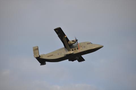
NASA’s P-3 Begins 2017 with IceBridge Support

The spring NASA Operation IceBridge campaign will take the P-3 to Greenland, Norway, and Alaska over the next 10 weeks. The P-3 last flew with IceBridge on their 2013 Arctic campaign, during which the aircraft made flights out of both Kangerlussuaq and Thule, Greenland.
NASA-Led Campaign Studies Hawaii’s Iconic Volcanoes

This month, a NASA-led science team is exploring Kilauea and the adjacent volcano Mauna Loa from the air, ground and space. Their goal: to better understand volcanic processes and hazards.
Probe May Improve Weather Forecasts

A weather probe that eventually will relay atmospheric conditions as they are unfolding and provide data to improve weather forecasts and models, has begun to fly on NASA’s Ikhana remotely piloted aircraft.
NASA Invites Media Behind the Scenes of Volcano, Coral Reef Research
, NOAA (right)")
NASA is hosting a media day on Feb. 8 in O’ahu, Hawaii, to spotlight two field campaigns that seek to unlock some of the mysteries behind two of Hawaii’s treasured natural resources: coral reefs and volcanoes.
Wallops Aircraft Supporting NASA Science Projects from Pole to Pole
The fleet of aircraft at the Wallops Flight Facility that support NASA’s airborne sciences program are preparing for a busy year as the agency continues several projects investigating critical scientific questions about how our planet is changing and what impacts humans are having on it.
NASA Airborne Mission Chases Air Pollution Through the Seasons

A NASA airborne mission will take a world-wide survey of these seasonal transformations by flying from the heart of winter in the Northern Hemisphere, down into the sunny summer in the Southern Hemisphere and back again
NASA Plans Another Busy Year for Earth Science Fieldwork

NASA scientists are crisscrossing the globe in 2017 – from a Hawaiian volcano to Colorado mountain tops and west Pacific islands – to investigate critical scientific questions about how our planet is changing and what impacts humans are having on it.
Navigating the Next Generation
 after a tour of the DC-8 at Osan Air Base in South Korea (April 2016). Credits: Emily Schaller / NASA")
Walter Klein travels all over the world as a navigator for NASA’s DC-8 airborne laboratory. On top of all of his responsibilities as DC-8 navigator, Klein has a deep commitment to sharing the excitement of NASA Airborne Science Program missions with students, teachers and the public.
NASA ER-2 Prepares to Support NOAA GOES-R Satellite

Over the next six months, NASA will be working with NOAA to calibrate sensors and validate data transmitted down from the Geostationary Operational Environmental Satellite (GOES-R) using NASA’s ER-2 high-altitude aircraft.
NASA Nears Finish Line of Annual Study of Changing Antarctic Ice

Operation IceBridge, NASA’s airborne survey of changes in polar ice, is closing in on the end of its eighth consecutive Antarctic deployment, and will likely tie its 2012 campaign record for the most research flights carried out during a single Antarctic season.
Getting to Know the Getz Ice Shelf

IceBridge, now in its eighth year, continues to build a record of how ice is responding to changes in the polar environment. The Getz Ice Shelf in West Antarctica is one area that scientists try to examine each year.
Studies Offer New Glimpse of Melting Under Antarctic Glaciers

Two new studies by researchers at NASA and the University of California, Irvine (UCI), detect the fastest ongoing rates of glacier retreat ever observed in West Antarctica and offer an unprecedented direct view of intense ice melting from the floating undersides of glaciers. The results highlight how the interaction between ocean conditions and the bedrock beneath a glacier can influence the glacier's evolution, with implications for understanding future ice loss from Antarctica and global sea level rise.
NASA Launches Eighth Year of Antarctic Ice Change Airborne Survey

IceBridge completed the first research flight of its 2016 Antarctic campaign on October 14. The campaign will continue through November 19. This year, the mission is based in Punta Arenas, a city at the southern tip of Chile. From there, IceBridge is carrying 12-hour flights back and forth to Antarctica, covering most of the western section of the frozen continent – the region that is experiencing the fastest changes and is Antarctica’s biggest contributor to sea level rise.
NASA/NOAA Team Deploy Global Hawk to Track Hurricane Matthew

NASA’s Global Hawk aircraft was deployed to Florida from Armstrong Flight Research Center at Edwards, CA. on Oct. 6 to monitor and take scientific measurements of Hurricane Matthew. The unmanned Global Hawk will gather scientific data in support of NOAA’s Sensing Hazards with Operational Unmanned Technology (SHOUT) mission.
NASA Using Aircraft to Measure Mid-Atlantic Greenhouse Gases

NASA is conducting low-level aircraft flights measuring greenhouse gases over the mid-Atlantic region through September. The flights are for the CARbon Airborne Flux Experiment or CARAFE, which will measure the exchange of greenhouse gases such as carbon dioxide and methane between the Earth and the atmosphere in the region. In addition, water vapor, temperature, and vertical wind measurements will be taken.
NASA Begins Study of Australia's Great Barrier Reef

A NASA airborne mission designed to transform our understanding of Earth's valuable and ecologically sensitive coral reefs has set up shop in Australia for a two-month investigation of the Great Barrier Reef, the world's largest reef ecosystem.
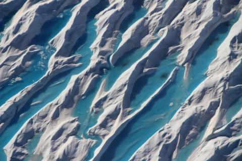
Science Flights Study Effect of Summer Melt on Greenland Ice Sheet

Operation IceBridge, NASA’s airborne survey of polar ice, is flying in Greenland for the second time this year, to observe the impact of the summer melt season on the ice sheet. The IceBridge flights, which began on Aug. 27 and will continue until Sept. 16, are mostly repeats of lines that the team flew in early May, so that scientists can observe changes in ice elevation between the spring and late summer.
NASA Global Hawk alerts NOAA of Gaston’s intensification

NOAA’s National Weather Service National Hurricane Center used real-time weather data from the NASA Global Hawk unmanned aircraft to upgrade a tropical storm to a hurricane in the early morning hours Thursday.
NASA Flies to Africa to Study Climate Effects of Smoke on Clouds
 is a unique natural laboratory with both persistent low-level clouds and a steady supply of tiny aerosol particles in the form of smoke from inland fires that mix with the clouds. Credits: NASA")
NASA scientists and two research aircraft are on their way to a unique natural laboratory off the Atlantic coast of southwest Africa to study a major unknown in future climate prediction.