Where No Map Leads: Reflections from NASA’s S-MODE Mission
It’s like stumbling through a thick forest and breaking out into a glade. A quiet has settled on this piece of sea as the waves calm. You can’t make a good map to get to this place. In the ocean, these glades are always moving, twisting, being born into life by the collision of great currents, then breaking apart, fracturing and sinking beneath the waves. The cold water brought from below by the coastal winds creates a fog that lies heavy on the sea surface, creating this small, calm spot.
Places like this can be found by things with nowhere else to go. Throw something off the side of a boat and it will likely end up somewhere like here. We’re at a convergence zone that attracts floating debris of all sizes. In particular, it attracts minuscule plankton, along with all the things that eat them and all the things that eat those things and so on and so on. All of it dragged hereby the undulating ocean.
Finding Nature at Sea During NASA’s S-MODE Field Campaign
My favorite part of being at sea is the opportunity to see unique parts of the natural world that aren’t accessible from land. My colleagues have done a fantastic job in their blog posts explaining the science that we’ve been conducting during S-MODE, so I want to take this opportunity to describe some of the sights that those of us on the Bold Horizon have been able to enjoy during our field work: birds, mammals, weather, and stars.
A First Cruise Experience with NASA’s S-MODE Field Campaign
I had been patiently waiting and dreaming about this research cruise for months. Yet a few days before traveling from Connecticut to Oregon for ship mobilization, I couldn’t shake a feeling of denial – like I couldn’t believe I was really going to be out in the Pacific Ocean on a research vessel for an entire month.
I am participating in NASA’s Sub-Mesoscale Ocean Dynamics Experiment (S-MODE) as part of the science party aboard the research vessel Bold Horizon. The focus of this experiment is to sample ocean fronts that are a few miles in size to study their dynamics and effects on vertical transport. The ocean fronts are sampled using aircraft, ship surveying, and autonomous platforms with names such as wave gliders, sea gliders, Saildrones, floats, and drifters. So being aboard the ship is just one piece of this complex research experiment.
Life at Sea: A “First-Timer” Chronicles NASA’s S-MODE Field Campaign
Going to sea for the first time as part of NASA’s S-MODE mission has been an experience like no other. You establish a new normal on the boat and quickly fall into new routines. Perceptions of time even change! I joked with some people on the boat that time is but a label on our samples. Perhaps that’s a bit dramatic, but normal perceptions of time do not apply at sea –especially if you start your day at 2 pm and finish at 2 am.
Student of the Sea: Learning the Ropes Aboard NASA’s S-MODE Mission
NASA’s S-MODE mission was designed to measure and understand the complex oceanic features classified as “submesoscale,” i.e., features spanning up to 6.2 miles (10 kilometers) across. Such fine filaments and sharp density fronts in the ocean are responsible for fast and unpredictable changes in velocity, temperature, salinity, and even among small organisms called plankton in the surface layer of the ocean. A myriad of autonomous instruments, airborne sensors, and a fully equipped ship are part of the robust methods of measuring submesoscale dynamics in the California Current region.
NASA’s S-MODE Field Campaign Deploys to the Pacific Ocean
When the research vessel Bold Horizon sailed from Newport, Oregon, in early October, it joined a small armada of planes, drones, and other high-tech craft chasing the ocean’s shapeshifting physics. NASA’s Sub-Mesoscale Ocean Dynamics Experiment (S-MODE) is converging on a patch of sea 110 nautical miles off the coast of San Francisco. Over the course of 28 days, the team will deploy a new generation of tools to observe whirlpools, currents, and other dynamics at the air-sea boundary. The goal: to understand how these dynamics drive the give-and-take of nutrients and energy between the ocean and atmosphere and, ultimately, help shape Earth’s climate.
Alaska’s Newest Lakes Are Belching Methane
“This lake wasn’t here 50 years ago.” Katey Walter Anthony, an ecologist at the University of Alaska-Fairbanks, dips her paddle into the water as her kayak glides across the lake. “Years ago, the ground was about three meters taller and it was a spruce forest,” she says. Big Trail Lake is a thermokarst lake, which means it formed due to permafrost thaw. Permafrost is ground that stays frozen year round; the permafrost in interior Alaska also has massive wedges of actual ice locked within the frozen ground. When that ice melts, the ground surface collapses and forms a sinkhole that can fill with water. Thus, a thermokarst lake is born.
IMPACTS Data User Workshop - 26-27 October 2022
We are currently planning our third IMPACTS Data User Workshop that will be held virtually on 26-27 October 2022 from 12:00-2:30 ET. These open data workshops enable our IMPACTS team to present important information to you (our potential IMPACTS data users) to help with your analysis of the data. For more information and to register, please click in the link below.
Walking Back in Time to Learn About the Future of Permafrost
There’s a freezer door in the mountainside outside of Fairbanks, Alaska. Tom Douglas opens it and we step inside, breathing in cold air and musky dust as we start to walk back through time. This isn’t fantasy. It’s the Permafrost Tunnel run by the U.S. Army’s Cold Regions Research and Engineering Laboratory in Alaska, where Douglas is a Senior Scientist. Recently, Douglas led a group of scientists and pilots with NASA’s Arctic Boreal Vulnerability Experiment (ABoVE) on a tour through the Tunnel to learn about permafrost. Permafrost is any soil, ice, or organic matter like plant material or bone that has stayed frozen year-round for at least two years. The tunnel was initially excavated in the 1960s and has been expanded since 2011. Now, the Permafrost Tunnel has almost 500 meters of excavation. “There’s just nowhere else on Earth that has this type of access to permafrost,” said Douglas.
Measuring Methane in the Everglades
The field campaign—called Blue Carbon Prototype Products for Mangrove Methane and Carbon Dioxide Fluxes (BLUEFLUX)—is designed to measure the methane and carbon dioxide changes at key wetlands around the Caribbean. Field teams took samples from the ground, while NASA’s Carbon Airborne Flux Experiment (CARAFE) aircraft measured methane emissions from the same locations from above. The broader goal of the campaign is to link ground and aerial data with satellite observations using machine learning and artificial intelligence algorithms in order to produce a daily methane flux dataset for the Caribbean region.
SARP Ozone Sondes Coincide with SAGE III/ISS Measurements
A NASA student research program recently took to the stratosphere to make ozone measurements that coincided with events from the Stratospheric Aerosol and Gas Experiment (SAGE) III on the International Space Station (ISS), an instrument developed at NASA’s Langley Research Center in Hampton, Virginia.
Toward Greater Diversity in Earth Sciences: NASA’s Student Airborne Science Activation Program
Understanding Earth and the complex influences on our planet’s climate are some of the biggest challenges of our times, and we need all the help we can get to tackle them. But, in the last 40 years, the minority representation in geosciences – meaning Earth, atmosphere, and ocean sciences – has remained relatively low despite its increase in proportion of the U.S. population. This summer, in an effort to address that, a new NASA program welcomed its first class of students.
NASA Flies Students on DC-8 to Study Air Quality
A group of university students and mentors flew aboard NASA Armstrong Flight Research Center’s DC-8 aircraft to study air quality as part of NASA’s Student Airborne Research Program (SARP).
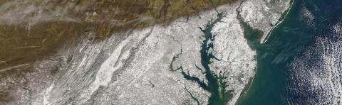
NASA Aircraft Conducting Atmospheric Studies Over DC to Baltimore
A NASA aircraft will fly over the I-95 corridor from Washington to Baltimore and Hampton, Virginia, in support of an atmospheric campaign in the mid-Atlantic region between July 5 and 16, 2022.
NASA Airborne Science Mission Engages with Students in Bermuda
A NASA airborne science mission conducting research flights over the Atlantic Ocean held an outreach event June 9 during a three-week deployment to Bermuda.
NASA’s ER-2 No. 806 Returns to Flight
NASA’s ER-2 high-altitude aircraft No. 806 returned to flight after three years of significant modifications and heavy maintenance.
NASA Uses Moonlight to Improve Satellite Accuracy
NASA’s airborne Lunar Spectral Irradiance, or air-LUSI, flew aboard NASA’s ER-2 aircraft from March 12 to 16 to accurately measure the amount of light reflected off the Moon. Reflected moonlight is a steady source of light that researchers are taking advantage of to improve the accuracy and consistency of measurements among Earth-observing satellites.
Student Airborne Researchers Fly on NASA’s DC-8
In December 2021, 53 students from various universities across the United States majoring in sciences, mathematics, and engineering were selected to fly on NASA Armstrong’s DC-8 Airborne Science Laboratory, as part of the NASA Ames’ Student Airborne Research Program (SARP).
Planning, Coordinating and Communicating: The Science Behind Winter Storm Chasing Experiments
As the snowstorm headed through New York on February 24, one professor at Stony Brook University in Stony Brook, New York spent the hours leading up to it preparing his students to head right into the storm.
IMPACTS 2022: NASA Planes Fly into Snowstorms to Study Snowfall
NASA’s Investigation of Microphysics and Precipitation for Atlantic Coast-Threatening Storms (IMPACTS) mission, which began in January and is planned to wrap up at the end of February, has seen upwards of 10 flights so far.
Storm Chasing Scientists Fly Into the Clouds to Understand Winter Snowstorms
Imagine the feeling of flying on an airplane. Smooth sailing, clear skies, not a cloud in sight. It’s a relaxing ride that many take for work or recreational travel. Now imagine flying through clouds, with the turbulence of different intensities. While some sink and hold onto their seats, others view it like a rollercoaster ride with their adrenaline pumping. Christian Nairy and Jennifer Moore know a thing or two about that.
IMPACTS 2022: NASA Planes Fly into Snowstorms to Study Snowfall
Goddard Media Studios reports on IMPACTS - watch their video chronicles of our February 3rd science flight!
IMPACTS Media Day 2022
PI Lynn McMurdie and pilots Rod Turbak and Greg “Coach” Nelson answer questions about IMPACT. Watch the YouTube video here.
Up, up and away: Launching Balloons in a Blizzard
Andrew Janiszeski and Troy Zaremba blow up a weather balloon in a dark hotel lobby. The weather was calm last night when they drove into Plymouth, Massachusetts, but this morning a blizzard is raging outside. Snow is piling up in the hotel parking lot, wind gusts are near 70mph, and the power is out – but they have a job to do.
NASA Planes Fly into Snowstorms to Study Snowfall
Scientists repeatedly check the weather forecasts as they prepare aircraft for flight and perform last-minute checks on science instruments. There’s a large winter storm rolling in, but that’s exactly what these storm-chasing scientists are hoping for.
Exploring Earth: Student Airborne Researchers fly on NASA’s DC-8
After a year delay due to the COVID-19 pandemic, 53 students flew on NASA’s DC-8 as part of NASA’s Student Airborne Research Project (SARP).
Now in its thirteenth year, SARP offers opportunities to undergraduate students from various universities across the United States who are majoring in sciences, mathematics, and engineering to participate in a NASA research campaign.
NASA Invites Media to Learn About S-MODE Mission
NASA held a media teleconference on Friday, Oct. 29 to share information about the Sub-Mesoscale Ocean Dynamics Experiment (S-MODE), a campaign to study small ocean whirlpools, eddies, and currents. Understanding small-scale ocean dynamics will help scientists better understand how Earth’s oceans help slow climate change.
Instruments in the Sea and Sky: NASA’s S-MODE Mission Kicks off 1st Deployment
Using instruments at sea and in the sky, the Sub-Mesoscale Ocean Dynamics Experiment (S-MODE) team aims to understand the role these ocean processes play in vertical transport, the movement of heat, nutrients, oxygen, and carbon from the ocean surface to the deeper ocean layers below. In addition, scientists think these small-scale ocean features play an important role in the exchange of heat and gases between air and sea. Understanding small-scale ocean dynamics will help scientists better understand how Earth’s oceans slow the impact of global warming and impact the Earth climate system.
NASA Study Examines Houston-area Air Quality Issues
NASA scientists are in Houston this month for an intensive air quality study exploring the effects of emissions and weather on air pollution, as well as the relationship between air quality and socioeconomic factors.
Backyard Science: NASA Airborne Science Interns Collect Data from Home
For more than a decade, dozens of students from across the United States traveled to California to collect air samples aboard NASA research aircraft. Since 2009, about 30 students every year have studied Earth and airborne science as part of the NASA Student Airborne Research Program, or SARP, summer internship. Although COVID-19 restrictions impacted SARP 2020 and lingered in 2021, student interns continued to receive hands-on research experience using Earth and atmospheric science datasets.


 and Avery Snyder (right) getting ready to deploy a mixed layer float. Credit: Alex Kinsella")

. Credit: Erin Czech.")
 in the Pacific Ocean off the U.S. West Coast. Credits: Ben Hodges / Woods Hole Oceanographic Institution (WHOI)")


 program pose in front of the agency’s P-3 aircraft, July 9, 2022, at NASA’s Wallops Flight Facility on Wallops Island, Virginia. Participants flew aboard the P-3 to collect Earth science data for their research. SaSa aims to increase diversity in the geosciences by providing students from minority-serving institutions with research experience and professional support. Pictured here are SaSa participants Camila Hernandez (left), Neima Dedefo, Michelle Garcia (back), Sophia Ramirez (front), Romina Cano Velasquez, and Trisha Joy Francisco (right).")


, the communication drops off and contact is lost with the system. Photo Courtesy of Brian Colle.")