
A scientific investigation is looking into how ozone forms and how it's being transported around the Long Island Sound. Led by the Northeast States for Coordinated Air Use Management (NESCAUM), the Long Island Sound Tropospheric Ozone Study (LISTOS) involves researchers from state and federal agencies and academia. Two NASA centers — Langley Research Center in Hampton, Virginia, and Goddard Space Flight Center in Greenbelt, Maryland — are contributing scientists, pilots, aircraft and aircraft-based remote sensing instruments to the effort.
News
Student Airborne Research Program Celebrates Tenth Year

Twenty-eight undergraduate students are participating in an eight-week NASA airborne science program field experience designed to immerse them in the agency's Earth Science research.
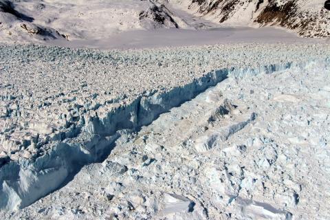
Dirty, Crevassed Glaciers in Alaska

Over the years, scientists have captured spectacular photographs while mapping ice during NASA’s Operation IceBridge mission. Many of the photographs have featured the icy landscapes of Greenland and Antarctica, over which lengthy missions are flown each year over. But the views during shorter duration IceBridge missions over Alaska reveal some equally majestic icescapes.
ACT-America: The Story So Far

A NASA airborne science study looking at the transport of two major greenhouse gases in the eastern half of the U.S. just completed its fourth and next-to-last flight campaign. By measuring how weather systems move carbon dioxide and methane, Atmospheric Carbon and Transport-America, or ACT-America, aims to improve our understanding of where the gases originate and where they're being absorbed. Flight campaigns have covered summer, fall, winter and spring. A final set of flights in 2019 will take a second look at summer, which is a particularly active time for greenhouse gas transport. In this video, ACT-America scientists talk about what the study is revealing so far, the challenges of conducting a multi-year airborne science campaign, and what they hope ACT-America's legacy will be.
Help from Above: NASA Aids Kilauea Disaster Response

On May 3, the Kilauea volcano on Hawaii’s Big Island erupted from new fissures and sent lava flowing over streets and neighborhoods. As the disaster response on the ground lead by the U.S. Geological Survey kicked into gear, managers from NASA’s Earth Science Disasters Program heard from response agencies and sent out a call to NASA’s own researchers, data managers, and satellite teams: What can we do to help?
NASA Completes Survey Flights to Map Arctic Ice

Operation IceBridge, NASA’s longest-running airborne mission to monitor polar ice change, concluded this year’s springtime survey of Arctic sea and land ice.
New Technology Doubles Scientists’ View of Ocean-Air Interactions

NASA scientists are hard at work trying to unlock mysteries of our planet’s ocean surface currents and winds using a new Earth science radar instrument called DopplerScatt.
NASA's World Tour of the Atmosphere Reveals Surprises Along the Way

Since 2016, a team of scientists with 25 advanced instruments aboard NASA's DC-8 research aircraft has sampled over 400 different gases and a broad range of airborne particles on month-long excursions from Alaska down the Pacific to New Zealand, then over to South America and up the Atlantic to Greenland, and across the Arctic Ocean. Far from land, the atmosphere above the ocean is where to find the cleanest air on the planet — at least in theory. Over the course of three deployments, and with their fourth and final trek beginning in late April, the team has found surprising levels of pollutants above the Pacific, Atlantic and Arctic oceans.
NASA Begins Latest Airborne Arctic Ice Survey

NASA completed the first IceBridge flight of its spring Arctic campaign with a survey of sea ice north of Greenland. This year marks the tenth Arctic spring campaign for IceBridge. The flights continue until April 27 extending the mission’s decade-long mapping of the fastest-changing areas of the Greenland Ice Sheet and measuring sea ice thickness across the western Arctic basin.
Taking the Pulse of Greenhouse Gases

NASA's King Air B200 aircraft was flown to test the triple-pulse Integrated Path Differential Absorption (IPDA) lidar, a first-of-its-kind instrument that measures atmospheric carbon dioxide (CO2) and water vapor (H2O).
NASA’s Longest Running Survey of Ice Shattered Records in 2017

Last year was a record-breaking one for Operation IceBridge, NASA’s aerial survey of the state of polar ice. For the first time in its nine-year history, the mission, which aims to close the gap between two NASA satellite campaigns that study changes in the height of polar ice, carried out seven field campaigns in the Arctic and Antarctic in a single year. In total, the IceBridge scientists and instruments flew over 214,000 miles, the equivalent of orbiting the Earth 8.6 times at the equator.
California Debris Flows Seen in Before/After Images from NASA's UAVSAR
 airborne radar platform detected changes caused by the debris flows between two images acquired on Nov. 2, 2017, and Feb. 5, 2018. An enhanced image pair (top left) shows disturbed areas in orange. In areas of severe surface disruption from the fire scar and debris flows the two image pairs can't be matched and decorrelate (top right). In the middle panels, the radar images are overlaid on the structure damage map produced by the County of Santa Barbara. The fire scars and damage correspond well with the risk map (lower left) and damage map (lower right). With an operational system, products such as these have the potential to augment information available for search and rescue, and for damage assessment for government agencies or the insurance industry. Radar has the advantage of being available in all weather conditions, as it can image through clouds.")
Extreme winter rains in January 2018 following the Thomas Fire in Ventura and Santa Barbara Counties caused severe debris flows, resulting in significant loss of life and considerable property damage in the town on Montecito, just east of Santa Barbara. NASA's Uninhabited Aerial Vehicle Synthetic Aperture Radar (UAVSAR) airborne radar platform detected changes caused by the debris flows between two images acquired on Nov. 2, 2017, and Feb. 5, 2018. An enhanced image pair (top left) shows disturbed areas in orange. In areas of severe surface disruption from the fire scar and debris flows the two image pairs can't be matched and decorrelate (top right). In the middle panels, the radar images are overlaid on the structure damage map produced by the County of Santa Barbara. The fire scars and damage correspond well with the risk map (lower left) and damage map (lower right). With an operational system, products such as these have the potential to augment information available for search and rescue, and for damage assessment for government agencies or the insurance industry. Radar has the advantage of being available in all weather conditions, as it can image through clouds.
NASA Takes International Aviation Research to the ‘Max’

NASA’s ongoing research into what happens with engine performance, emissions and contrail formation when different types of fuels are used in jet engines is headed for the skies over Germany this month.
NASA Covers Wildfires from Many Sources

NASA has a fleet of research aircraft carrying the latest sensor technologies that can be used for Earth observations. NASA's ER-2 aircraft, based at Armstrong Flight Research Center (AFRC) in Palmdale, California, flies as high as 70,000 feet (21,300 meters), almost twice as high as a commercial airliner, and is used for science research missions over much of the world. In December 2017, the aircraft flew locally over California wildfire events, testing early versions of science instruments that may one day be launched into space aboard a satellite to observe our home planet Earth.
Prototype Space Sensors Take Test Ride on NASA ER-2

Scientists recently completed test flights with prototypes of potential satellite sensors over the Western United States probing basic science questions about aerosols, clouds, air quality and global ocean ecosystems.
NASA ER-2 Aircraft Flies Over Thomas Fire in California

During an engineering flight test of the Cloud-Aerosol Multi-Angle Lidar (CAMAL) instrument, a view from NASA Armstrong Flight Research Center’s ER-2 aircraft shows smoke plumes, from roughly 65,000 feet, produced by the Thomas Fire in Ventura County, California, around 1 p.m. PST on Dec. 5th, 2017. As of Dec. 6, authorities state 65,000 acres have been burned and the fire remains zero percent contained.
Image Credit: NASA/Stu Broce
New Greenland Maps Show More Glaciers at Risk
 below sea level (dark blue) to 4,900 feet above sea level (brown). Right: regions below sea level connected to the ocean, either shallower than 600 feet (200 meters, light pink); between 600 and 1,000 feet (300 meters, dark pink); or continuously deeper than 1,000 feet below sea level (dark red). The thin white line shows the current extent of the ice sheet. Credits: UCI")
New maps of Greenland’s coastal seafloor and bedrock beneath its massive ice sheet show that two to four times as many coastal glaciers are at risk of accelerated melting as previously thought.
Researchers at the University of California at Irvine (UCI), NASA and 30 other institutions have published the most comprehensive, accurate and high-resolution relief maps ever made of Greenland's bedrock and coastal seafloor. Among the many data sources incorporated into the new maps are data from NASA's Ocean Melting Greenland (OMG) campaign.
IceBridge Launches Two Sets of Antarctic Flights

Scientists with NASA’s longest-running airborne mission to map polar ice, Operation IceBridge, completed a successful science flight on Oct. 29, inaugurating their 2017 survey of Antarctic sea and land ice. For the first time in its nine years of operations in the southern hemisphere, IceBridge will launch two consecutive, dedicated sets of Antarctic flights from two continents—South America and Antarctica—with two different aircraft and instrument suites.
ACT-America Aims to Tell Four-Season Greenhouse Gas Story

NASA scientists are once again on the hunt for greenhouse gases in the sky. Researchers for the Atmospheric Carbon and Transport-America, or ACT-America, study returned to the field last week to measure how weather systems transport carbon dioxide and methane through the atmosphere over the eastern part of the United States.
Global Airborne Mission to Make Ozone Hole Detour

Atmospheric researchers depart this month on NASA's DC-8 research aircraft on their third survey of the global atmosphere. Taking place for the first time in Northern Hemisphere fall, the season gives them the unique opportunity to make a detour from their previous flight paths to fly underneath the Antarctic ozone hole.
NASA Flights Map Summer Melt of Greenland Land Ice

Operation IceBridge is flying in Greenland to measure how much ice has melted over the course of the summer from the ice sheet. The flights, which began on Aug. 25 and will go on until Sept. 21, repeat paths flown this spring and aim to monitor seasonal changes in the elevation of the ice sheet.
NASA Chesapeake Bay Study To Help Improve Air-Quality Forecasts

The Ozone Water-Land Environmental Transition Study (OWLETS) is a NASA study looking at ozone concentrations around the lower Chesapeake Bay.
NAAMES Returns to Air and Sea to Study Plankton’s Annual Cycle

NASA’s North Atlantic Aerosols and Marine Ecosystems Study (NAAMES) returned to air and sea to research the declining, or deaccelerating, phase of the annual cycle of plankton in the North Atlantic. Since plankton form the base of the marine food web and impact the productivity of fisheries, understanding this declining phase is important to forecasting the future.
NASA Interns Complete Earth Science Summer Research Program
, Whole Air Sampling (upper right), Ocean Remote Sensing (lower left), Land Vegetation Remote Sensing (lower right). Students posed with their groups after the completion of their final research presentations on August 8 and 9, 2017 at the University of California Irvine. Credits: NASA / Megan Schill")
Thirty-two students from colleges and universities across the United States recently completed a NASA summer internship designed to provide them with an airborne Earth science research experience.
NASA Scientists Seek to Improve Sea Ice Predictions

NASA researchers are working to improve their forecasts of the size of the Arctic sea ice cover at the end of the summer melt season — but the goal is not just to have a better prediction of sea ice coverage. The challenge of making summer sea ice forecasts allows scientists to test their understanding of the processes that control seasonal sea ice growth and retreat, and to fine-tune computer models that represent connections among the ice, atmosphere and ocean.
On Aircraft, Armstrong Kicks off NASA TV Coverage of Solar Eclipse

A photographer and videographers from NASA Armstrong Flight Research Center in California will document the total solar eclipse Aug. 21, which they will be doing from a unique vantage point at about 25,000 feet altitude.
NASA-led Airborne Mission Studies Storm Intensification in Northern Hemisphere

A group of NASA and National Oceanic Atmospheric Administration (NOAA) scientists are teaming up this month for an airborne mission focused on studying severe storm processes and intensification. The Hand-On Project Experience (HOPE) Eastern Pacific Origins and Characteristics of Hurricanes (EPOCH) field campaign will utilize NASA’s Global Hawk autonomous aircraft to study storms in the Northern Hemisphere to learn more about how storms intensify as they brew out over the ocean.
NASA Airborne Mission Returns to Africa to Study Smoke, Clouds

NASA's P-3 research plane begins flights this month through both clouds and smoke over the South Atlantic Ocean to understand how tiny airborne particles called aerosols change the properties of clouds and how they influence the amount of incoming sunlight the clouds reflect or absorb.
Two Decades of Changes in Helheim Glacier
Since 1997, NASA has collected data over Helheim Glacier almost every year during annual airborne surveys of the Greenland Ice Sheet using an airborne laser altimeter called the Airborne Topographic Mapper (ATM). Since 2009 these surveys have continued as part of Operation IceBridge, NASA’s ongoing airborne survey of polar ice and its longest-running airborne mission. ATM measures the elevation of the glacier along a swath as the plane files along the middle of the glacier. By comparing the changes in the height of the glacier surface from year to year, scientists estimate how much ice the glacier has lost.
Chasing the Total Solar Eclipse from NASA’s WB-57F Jets

For most viewers, the Aug. 21, 2017, total solar eclipse will last less than two and half minutes. But for one team of NASA-funded scientists, the eclipse will last over seven minutes. Their secret? Following the shadow of the Moon in two retrofitted WB-57F jet planes.