
In an extensive airborne survey, a NASA-led team has analyzed a previously identified "hot spot" of methane emissions in the Four Corners region of the United States, quantifying both its overall magnitude and the magnitudes of its sources. The study finds that just 10 percent of the individual methane sources are contributing half of the emissions.
News
NASA Science Flights Target Melting Arctic Sea Ice

This summer, with sea ice across the Arctic Ocean shrinking to below-average levels, a NASA airborne survey of polar ice just completed its first flights. Its target: aquamarine pools of melt water on the ice surface that may be accelerating the overall sea ice retreat
NASA's Airborne Mission to Explore the Global Atmosphere

The Atmospheric Tomography, or ATom, mission is the first to survey the atmosphere over the oceans. Scientists aboard NASA's DC-8 flying laboratory will journey from the North Pole south over the Pacific Ocean to New Zealand and then across to the tip of South America and north up the Atlantic Ocean to Greenland. ATom will discover how much pollution survives to the most remote corners of the earth and assess how the environment has changed as a result.
NASA Flights to Track Greenhouse Gases Across Eastern US

Atmospheric Carbon and Transport–America, or ACT-America, is a multi-year airborne campaign that will measure concentrations of carbon dioxide and methane in relation to weather systems. The study will gather real-time measurements from research aircraft and ground stations to improve the ability to detect and quantify the surface sources and sinks of the gases.
NASA Maps California Drought Effects on Sierra Trees
 and sugar (P. lambertiana) pine on the Hume Lake Ranger District, Sequoia National Forest, California. Credits: USDA Forest Service")
A new map created with measurements from an airborne instrument developed by NASA’s Jet Propulsion Laboratory, Pasadena, California, reveals the devastating effect of California’s ongoing drought on Sierra Nevada conifer forests.
Students to Study Air Quality
, physics major at University of California Merced, and Mariah Heck (right), geophysics and geology major at University of Tulsa hold signs to welcome home the DC-8 crew home from the Korean U.S. Air Quality mission. Credits: NSERC Photo / Jane Peterson")
Starting this week, 32 undergraduate students begin an eight-week NASA airborne science field experience designed to immerse them in the agency's Earth science research.
Earth Expeditions: Josh Willis OMG Mission Update
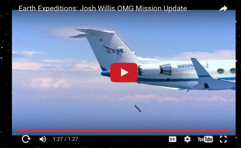
On Friday June 3, 2016, the Oceans Melting Greenland mission had its first successful test of the system for dropping ocean probes from the Gulfstream-III aircraft into the ocean. The team dropped a single probe into the Gulf of Mexico about 100 miles offshore of Houston as a T-38 chase aircraft monitored. Learn more about OMG and #EarthExpeditions: http://www.nasa.gov/earthexpeditions
NASA’s Operation IceBridge Completes 2016 Arctic Spring Campaign

Operation IceBridge, NASA’s airborne survey of polar ice, ended its eighth spring Arctic campaign on May 21. During their five weeks of operations, mission scientists carried out six research flights over sea ice and ten over land ice.
New NASA Instrument Brings Coasts and Coral into Focus

NASA's upcoming Coral Reef Airborne Laboratory (CORAL) field experiment will observe entire reef ecosystems in more of the world's reef area – hundreds of times more -- than has ever been observed before.
New Study Maps Rate of New Orleans Sinking

New Orleans and surrounding areas continue to sink at highly variable rates due to a combination of natural geologic and human-induced processes, finds a new NASA/university study using NASA airborne radar.
All in the NAAMES of Ocean Ecosystems and Climate
NAAMES, or the North Atlantic Aerosols and Marine Ecosystems Study, is a five-year NASA-funded study that aims to better define the relationship between the ocean and the atmosphere. NAAMES is the first NASA Earth Venture-Suborbital mission focused on studying the coupled ocean ecosystem and atmosphere using ships and aircraft simultaneously.
Airborne Expedition Tackles Global Air Quality Problem

Next week NASA and the Republic of Korea’s National Institute of Environmental Research (NIER) embark on the collaborative Korea United States Air Quality study (KORUS-AQ). The KORUS-AQ field campaign will combine observations from aircraft, satellites, ships and ground stations with air quality models to assess and monitor air quality across urban, rural and coastal areas.
IceBridge Begins Eighth Year of Arctic Flights

Operation IceBridge, NASA’s airborne survey of polar ice, completed its first Greenland research flight of 2016 on April 19, kicking off its eighth spring Arctic campaign. This year’s science flights over Arctic sea and land ice will continue until May 21.
Airborne Mission Looks at Fires and Cooling Atlantic Cloud Decks
 from biomass burning fires over southern Africa, which move westward with the prevailing tropical winds. ORACLES will try to answer the question of how these smoke layers interact with the underlying clouds and affect the amount of sunlight they reflect back to space. Credits: NASA")
A new NASA airborne field experiment planned for this summer will make key airborne measurements of clouds and smoke particles over the southeastern Atlantic Ocean to help scientists understand a major challenge to our understanding of climate science.
NASA Gets Down to Earth This Year With Globe-Spanning Expeditions

NASA is sending scientists around the world in 2016 – from the edge of the Greenland ice sheet to the coral reefs of the South Pacific – to delve into challenging questions about how our planet is changing and what impacts humans are having on it.
Airborne Study Surveys Greenhouse Gases in World Tour

The first deployment of one of NASA's most ambitious research studies of Earth's atmosphere will take place this July and August. The Atmospheric Tomography mission will take off aboard the agency's DC-8 flying laboratory on a 26-day journey from the North Pole down the Pacific Ocean to New Zealand and then across to the tip of South America and back north up the Atlantic Ocean to the Arctic.
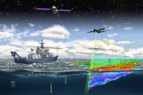
Q&A with Oceans Melting Greenland scientist Josh Willis

The new NASA airborne mission Oceans Melting Greenland (OMG) will pave the way for improved estimates of sea level rise by addressing the question: To what extent is the ocean melting Greenland’s ice from below? The mission will observe changing water temperatures and glaciers that reach the ocean around Greenland from 2015 to 2020. The OMG data set will complement earlier and ongoing observations of Greenland's melting ice sheet by satellite sensors such as the Gravity Recovery and Climate Experiment (GRACE), which gives a precise measurement of the loss of mass from Greenland, and other airborne programs including NASA's Operation IceBridge, which measures bedrock topography and the depth of the overlying snow and ice.
NASA, Partner Space Agencies Measure Forests In Gabon
 carries a laser altimeter, while the C-20A aircraft (right) transports a radar. Both instruments collect measurements of surface topography and vegetation structure, creating 3D maps of their targets.")
A contingent of NASA airborne instruments and scientists on the ground has joined colleagues from space agencies in Gabon and Europe this month to study the dense African tropical forests in Gabon.
NASA Partners on Air Quality Study in East Asia

NASA and the Republic of Korea are developing plans for a cooperative field study of air quality in May and June to advance the ability to monitor air pollution accurately from space. The Korea U.S.-Air Quality study (KORUS-AQ) will assess air quality across urban, rural and coastal areas of South Korea using the combined observations of aircraft, ground sites, ships and satellites. Findings will play a critical role in the development of observing systems of ground and space-based sensors and computer models to provide improved air quality assessments for decision makers.
NASA Global Hawk to Begin NOAA El Nino Storm Mission
 El Niño Rapid Response Field Campaign. The mission, called Sensing Hazards Operational Unmanned Technology or SHOUT, will focus on gathering El Niño storm data out over the Pacific Ocean. Credits: NASA / Jim Ross NASA and NOAA are teaming up again to send NASA’s remotely piloted Global Hawk out over the Pacific to take a closer look at storms brewed by this year’s strong El Niño. The observation flights are part of an ongoing NOAA mission, called Sensing Hazards with Operational Unmanned Technology (SHOUT). Based from NASA’s Armstrong Flight Research Center in Edwards, California, the Global Hawk will fly four to six 24-hour flights during the month of February. The mission will provide detailed meteorological measurements from a region in the Pacific that is known to be particularly critical for interactions linked to West Coast storms and rainf")
NASA and NOAA are teaming up again to send NASA’s remotely piloted Global Hawk out over the Pacific to take a closer look at storms brewed by this year’s strong El Niño. The observation flights are part of an ongoing NOAA mission, called Sensing Hazards with Operational Unmanned Technology (SHOUT).
NASA Radar Brings a New View of World Heritage Site

In just two 10-minute overflights, an airborne NASA synthetic aperture radar proved it could pinpoint areas of disturbance in Peru's Nasca lines World Heritage Site. The data collected on the two flights will help Peruvian authorities fully catalog the thousand-year-old designs drawn on the ground in and around the site for the first time, as well as giving them a new tool for protecting the fragile constructions from both careless humans and natural disturbances such as floods.
Methane Emissions in Arctic Cold Season Higher Than Expected

The amount of methane gas escaping from the ground during the long cold period in the Arctic each year and entering Earth’s atmosphere is likely much higher than estimated by current carbon cycle models, concludes a major new study led by San Diego State University and including scientists from NASA’s Jet Propulsion Laboratory, Pasadena, California.
NASA Study to Look at the Immense Influence of Petite Plankton

The North Atlantic Aerosols and Marine Ecosystems Study (NAAMES) is an interdisciplinary investigation resolving key processes controlling marine ecosystems and aerosols that are essential to our understanding of Earth system function and future change.
NASA Heads to Pacific Northwest for Field Campaign to Measure Rain and Snowfall

From Nov. 10 through Dec. 21, NASA and university scientists are taking to the field to study wet winter weather near Seattle, Washington. With weather radars, weather balloons, specialized ground instruments, and NASA's DC-8 flying laboratory, the science team will be verifying rain and snowfall observations made by the Global Precipitation Measurement (GPM) satellite mission.
NASA to Fly, Sail North to Study Plankton-Climate Change Connection
.")
NASA begins a five-year study this month of the annual cycle of phytoplankton and the impact that small airborne particles emitted from the ocean have on the climate-sensitive North Atlantic.
NASA Study Improves Understanding of LA Quake Risks

A new NASA-led analysis of a moderate magnitude 5.1 earthquake that shook Greater Los Angeles in 2014 finds that the earthquake deformed Earth's crust across a broad region encompassing the northern Los Angeles Basin and northern Orange County.
Tour NASA's Extreme Weather Research Work

Social media users are invited to apply for media credentials to go inside NASA's DC-8 flying laboratory Nov. 11 at the University of Washington in Seattle and learn about the science behind NASA's stunning three-dimensional views of hurricanes, storms, falling rain and snow. Attendees also will get a close-up look at the OLYMPEX campaign, which focuses on tracking precipitation over mountainous terrain that is difficult to measure.
New Video Highlights 3 Years of NASA Hurricane Research

NASA's Hurricane and Severe Storm Sentinel, or HS3, mission investigated tropical cyclones in the 2012, 2013 and 2014 Atlantic Basin hurricane seasons. Highlights of the mission can be seen in a new video.
NASA to Fly Parallel Science Campaigns at Both Poles

For the first time in its seven years of flights, NASA's Operation IceBridge, an airborne survey of changes in Earth’s polar ice, is conducting overlapping campaigns in Antarctica and the Arctic.
Greenland Campaign Takes Flight for Better Ice Sheet Measurements
 Credits: NASA/Mike Wusk")
A NASA instrument nestled in the belly of a small plane flew over Greenland’s ice sheet and the Arctic Ocean’s icy waters. Flying above creviced glaciers, chunks of ice floating in melt ponds, and the slushy edges of the ice sheets, the instrument used a rapidly firing laser to measure the elevation of the surface below.