Led by NASA, the U.S. Naval Research Laboratory (NRL) and the Manila Observatory in conjunction with the Philippine Atmospheric, Geophysical and Astronomical Services Administration and the Philippine Department of Science and Technology, CAMP2Ex comprises an interdisciplinary, international team of field researchers, modelers and remote sensing developers.
News
NASA Studies How Arctic Wildfires Change the World

Wildfires in the Arctic often burn far away from populated areas, but their impacts are felt around the globe. From field and laboratory work to airborne campaigns and satellites, NASA is studying why boreal forests and tundra fires have become more frequent and powerful and what that means for climate forecasting, ecosystems and human health.
Student Airborne Research Program Takes Flight over California

Twenty-eight undergraduate students are participating in an eight-week NASA airborne science field experience this summer that will immerse them in the agency's Earth Science research.
Through Smoke and Fire, NASA Searches for Answers

This summer, NASA is embarking on several field campaigns across the world to investigate longstanding questions surrounding fire and smoke. Aircraft will fly through smoke and clouds to improve air quality, weather and climate forecasting, and investigate fire-burned forests to capture ecosystem changes that have global impact.
Study Predicts More Long-Term Sea Level Rise from Greenland Ice

Greenland’s melting ice sheet could generate more sea level rise than previously thought if greenhouse gas emissions continue to increase and warm the atmosphere at their current rate, according to a new modeling study. The study, which used data from NASA’s Operation IceBridge airborne campaign, was published in Science Advances today.
Looking For Freshwater In All the Snowy Places

Snowflakes that cover mountains or linger under tree canopies are a vital freshwater resource for over a billion people around the world. To help determine how much freshwater is stored in snow, a team of NASA-funded researchers is creating a computer-based tool that simulates the best way to detect snow and measure its water content from space.
NASA Explores Our Changing Freshwater World

Researchers funded by NASA have used satellite and airborne data to better inform existing tools for flooding, drought forecasts and famine relief efforts, and for planning and monitoring regional water supplies. These efforts are tackling some of the most pressing needs of people around the world.
Modified spy plane to see whether towering storms pose new threat to ozone layer

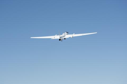
NASA's ER-2 is again preparing to soar to the overworld in search of a potential new threat to the ozone layer.
Illuminating Gases in The Sky: NASA Technology Pinpoints Potent Greenhouse Gases

Research scientists at NASA’s Langley Research Center in Hampton, Virginia, have created a new airborne instrument that can directly measure water vapor and floating particles in the atmosphere. The new data will help check the accuracy of satellite measurements, and improve weather and climate forecasts.
NASA Testing Airborne Lasers to Touch the Wind

A group of NASA researchers could soon be blown away by data they collect during an airborne science campaign that will span from the Pacific coast to Hawaii.
NASA Begins Final Year of Airborne Polar Ice Mission

This is the last year for Operation IceBridge, NASA’s most comprehensive airborne survey of ice change. Since the launch of its first Arctic campaign in spring 2009, IceBridge has enabled discoveries ranging from water aquifers hidden within snow in southeast Greenland, to the first map indicating where the base of the massive Greenland Ice Sheet is thawed, to detailed depictions of the evolving Arctic sea ice cover and the thickness of the overlying snow.
A Decade of Exploring Alaska’s Mountain Glaciers

In Alaska, 5 percent of the land is covered by glaciers that are losing a lot of ice and contributing to sea level rise. To monitor these changes, a small team of NASA-funded researchers has been flying scientific instruments on a bright red, single-engine plane since spring 2009.
Cold Water Currently Slowing Fastest Greenland Glacier

NASA research shows that Jakobshavn Glacier, which has been Greenland's fastest-flowing and fastest-thinning glacier for the last 20 years, has made an unexpected about-face. Jakobshavn is now flowing more slowly, thickening, and advancing toward the ocean instead of retreating farther inland. The glacier is still adding to global sea level rise — it continues to lose more ice to the ocean than it gains from snow accumulation — but at a slower rate.
Going Where the Wind Takes It

Developed at NASA's Langley Research Center in Hampton, Virginia, DAWN uses laser pulses to take highly accurate measurements of vector wind speed and direction. In the upcoming campaign, which will be based out of NASA's Armstrong Flight Research Center in Palmdale, California, scientists will use DAWN to validate measurements from Atmospheric Dynamics Mission Aeolus (ADM-Aeolus), a European Space Agency (ESA) satellite that profiles wind speeds across the globe.
NASA's Greenland Mission Still Surprises in Year Four

Only seven months after NASA's Oceans Melting Greenland (OMG) mission wrapped its last field campaign on the world's largest island, an OMG crew is back in Greenland to collect more data. With two or three field projects a year since 2016, no wonder OMG has made the most comprehensive measurements yet of how ocean water lapping at the undersides of Greenland's melting glaciers affects them. All that data has answered a lot of existing questions — and it's raised plenty of new ones.
NASA's Greenland Mission Still Surprises in Year Four

Only seven months after NASA's Oceans Melting Greenland (OMG) mission wrapped its last field campaign on the world's largest island, an OMG crew is back in Greenland to collect more data. With two or three field projects a year since 2016, no wonder OMG has made the most comprehensive measurements yet of how ocean water lapping at the undersides of Greenland's melting glaciers affects them. All that data has answered a lot of existing questions — and it's raised plenty of new ones.
NASA Finds Possible Second Impact Crater Under Greenland Ice

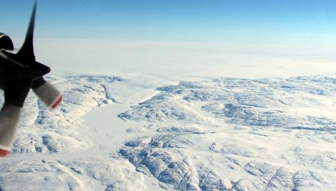
A NASA glaciologist has discovered a possible second impact crater buried under more than a mile of ice in northwest Greenland. This follows the finding, announced in November 2018, of a 19-mile-wide crater beneath Hiawatha Glacier – the first meteorite impact crater ever discovered under Earth’s ice sheets. Though the newly found impact sites in northwest Greenland are only 114 miles apart, at present they do not appear to have formed at the same time.
Huge Cavity in Antarctic Glacier Signals Rapid Decay

A gigantic cavity — two-thirds the area of Manhattan and almost 1,000 feet (300 meters) tall — growing at the bottom of Thwaites Glacier in West Antarctica is one of several disturbing discoveries reported in a new NASA-led study of the disintegrating glacier. The findings highlight the need for detailed observations of Antarctic glaciers' undersides in calculating how fast global sea levels will rise in response to climate change.
NASA Mobilizes to Aid California Fires Response

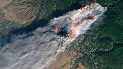
For the past two weeks NASA scientists and satellite data analysts have been working every day producing maps and damage assessments that can be used by disaster managers battling the Woolsey Fire near Los Angeles and the Camp Fire in Northern California. The agency-wide effort also deployed a research aircraft over the Woolsey Fire on Nov. 15 to identify burned areas at risk of mudslides in advance of winter rains expected in the area.
International Team, NASA Make Unexpected Discovery Under Greenland Ice

An international team of researchers, including a NASA glaciologist, has discovered a large meteorite impact crater hiding beneath more than a half-mile of ice in northwest Greenland. The crater — the first of any size found under the Greenland ice sheet — is one of the 25 largest impact craters on Earth, measuring roughly 1,000 feet deep and more than 19 miles in diameter, an area slightly larger than that inside Washington’s Capital Beltway.
Massive Antarctic Iceberg Spotted on NASA IceBridge Flight

NASA’s Operation IceBridge flew over an iceberg that is three times the size of Manhattan – the first time anyone has laid eyes on the giant iceberg, dubbed B-46 by the U.S. National Ice Center, that broke off from Pine Island Glacier in late October.
African Smoke-Cloud Connection Target of NASA Airborne Flights

This month, NASA's P-3 research aircraft and a team of scientists return on their third deployment to this region as part of the Observations of Aerosols Above Clouds and their Interactions mission, or ORACLES, gathering data on how aerosols such as smoke affect clouds and in turn Earth's climate.
Operation IceBridge, ICESat-2 Join Forces To Survey Antarctica

NASA’s decade-long airborne survey of polar ice, Operation IceBridge, is once again probing Antarctica. But this year is different: it is the first time that the IceBridge team and instruments survey the frozen continent while NASA’s newest satellite mission, the Ice, Cloud and land Elevation Satellite-2 (ICESat-2), studies it from space.
NASA Airborne Team Surveys Flooding from Hurricane Florence

In the aftermath of Hurricane Florence, which struck the Carolinas on Sept. 14 causing widespread damage, NASA quickly deployed a sophisticated airborne radar to give disaster response agencies a much-needed view of floodwaters that continued to threaten the region.
Finding Open Water in Greenland's Icy Seas

Researchers in NASA's Oceans Melting Greenland campaign release scientific probes from an airplane into the seawater along the coast of Greenland. The probes are part of a five-year effort to improve our understanding of the ocean's role in Greenland's rapid ice loss.
New Airborne Campaigns to Explore Snowstorms, River Deltas, Climate

Five new NASA Earth science campaigns will take to the field starting in 2020 to investigate a range of pressing research questions, from what drives intense East Coast snowfall events to the impact of small-scale ocean currents on global climate.
Mapping Record-Setting Wildfire from 65,000 Feet

The Mendocino Complex Fire is now the largest wildfire in California history with well over 350,000 acres burned. This false-color image was captured on August 9, 2018 by an instrument installed aboard a NASA research aircraft that flew over both fires making up the complex in the area around Clear Lake (the central, black feature) in northern California. Active fire zones are seen in yellow, with warm, burned areas in orange. Unburned vegetation appears in blue and green. The flames of small, active fires can be seen at the leading edges of the fire perimeter.
NASA Assists in Efforts to Contain California Wildfires

An effort by multiple NASA centers to assist with the California wildfires included capturing satellite data of the smoke plumes and aircraft flights over burned areas to collect information for recovery planning.
NASA Gets Up Close with Greenland's Melting Ice

With a new research plane and a new base to improve its chances of outsmarting Atlantic hurricanes, NASA's Oceans Melting Greenland campaign takes to the sky this week for its third year of gathering data on how the ocean around Greenland is melting its glaciers.
Christy Hansen - A Force of Nature

Christy Hansen plans and manages airborne science missions. She helps scientists, engineers and managers to design aircraft-based Earth science missions including milestones and budget, science requirements definition, instruments and aircraft, field logistics and deployment operations, data management, documentation and reporting.

