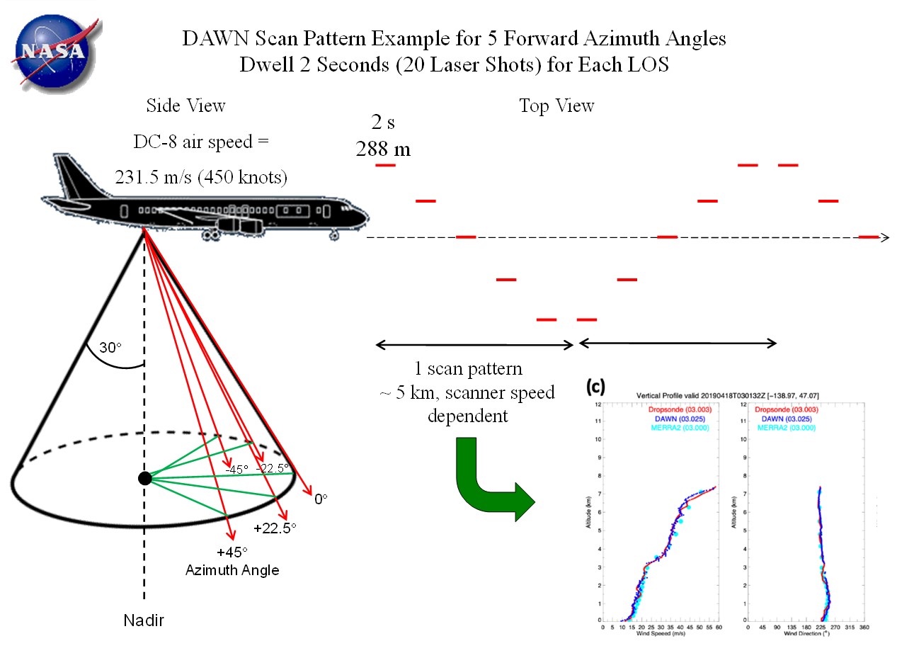
The NASA Langley Research Center DAWN (Doppler Aerosol WiNd) lidar system employs a pulsed, solid-state laser operating at 2053 nm wavelength. It pulses at 10 Hz with up to 100 mJ/pulse which are 180 ns long. Using a wedge scanner, several different azimuth angles can be measured below the aircraft, all at a 30 degree off-nadir angle. Multiple azimuth angles enable horizontal wind calculation, mitigate cloud obscurations, and measure atmospheric variability. DAWN can provide vertical profiles of the zonal (u) and meridional (v) components of the horizontal wind below the aircraft, typically at ~60 meter resolution. Various vertical and horizontal resolutions are possible in post processing. DAWN can also provide vertical profiles of line of sight (LOS) wind speed at each azimuth angle. It can also be operated to stare persistently at any particular azimuth angle to simulate what a satellite such as European Space Agency Atmospheric Dynamics Mission (ADM) Aeolus would observe. DAWN signal returns also permit retrieval of vertical profiles of relative aerosol backscatter, planetary boundary layer height, and wind turbulence.
Lidar
The Differential Absorption Lidar uses the backscatter of two simultaneous laser wavelengths through zenith and nadir windows to measure the vertical profiles of H2O and aerosols/clouds.
NASA's Lidar Atmospheric Sensing Experiment (LASE) system is an airborne DIAL (Differential Absorption Lidar) system used to measure water vapor, aerosols, and clouds throughout the troposphere. LASE probes the atmosphere using lasers to transmit light in the 815-nm absorption band of water vapor. Pulses of laser light are fired vertically below the aircraft. A small fraction of the transmitted laser light is reflected from the atmosphere back to the aircraft and collected with a telescope receiver. The received light indicates the amount of water vapor along the path of the laser beam.
Detailed topographic maps of very high accuracy are produced by airborne laser altimeter terrain mapping. The unique capabilities of this new technique yield more comprehensive and precise topographic information than traditional methods. Airborne laser altimeter data can be used to accurately measure the topography of the ground, even where overlying vegetation is quite dense. The data can also be used to determine the height and density of the overlying vegetation, and to characterize the location, shape, and height of buildings and other manmade structures.
The method relies on measuring the distance from an airplane, or helicopter, to the Earth’s surface by precisely timing the round-trip travel time of a brief pulse of laser light. The travel-time is measured from the time the laser pulse is fired to the time laser light is reflected back from the surface. The reflected laser light is received using a small telescope that focuses any collected laser light onto a detector. The travel-time is converted to distance from the plane to the surface based on the speed of light. Typically a laser transmitter is used that produces a near-infrared laser pulse that is invisible to humans. The laser light reaching the ground surface is completely safe. It can not cause any eye damage to a person who might be looking up at the plane as it flies overhead.
The Aerosol Lidar system measures profiles of aerosol and/or cloud backscatter at 532 and 1064 nm and aerosol/cloud depolarization at 532 nm. Backscatter profiles at these two wavelengths provide information on the relative concentration and spatial distribution of aerosol/cloud particles. Comparison of aerosol/cloud backscatter at the two wavelengths provides some indication of particle size. Measurement of the depolarizing effect of the particles (that is, the degree to which the polarization of the backscattered light from the particles differs from the linear polarization of the transmitted laser light) provides an indication of particle phase.
The Aerosol Lidar is a piggy-back instrument on AROTEL lidar fielded by John Burris and Tom McGee of NASA Goddard Space Flight Center. The light source for the aerosol measurements is a Continuum 9050 Nd:YAG laser operating at 50 shots per second. The laser transmits approximately 600 mJ at 1064 nm, 250 mJ at 532 nm, and 350 mJ at 355 nm. AROTEL also employs an excimer laser transmitting at 308 nm and uses the molecular and Raman backscatter from the 355 and 308 beams to measure ozone and temperature. Backscattered light at all wavelengths is collected by a 16-inch diameter Newtonian telescope with a selectable field stop. In the aft optics assembly following the telescope and field stop, the UV signals are separated from the 532- and 1064-nm signals by a dichroic beam splitter. The UV signals are directed to the AROTEL receiver assembly and the 532- and 1064-nm signals are directed to the Aerosol Lidar receiver assembly. In the Aerosol Lidar receiver, a rotating shutter blocks the very strong near-range 532- and 1064-nm signals in order to reduce distortion in the relatively weaker signals from higher altitudes. The 532- and 1064-nm signals are separated by a dichroic beam splitter and the 532-nm signal is further separated into orthogonal polarization components using a polarizing beam cube. A computer-controlled half-wave plate in front of the polarizing beam cube is rotated so that the polarization of the 532 signals are parallel and perpendicular to the polarization of the transmitted laser pulses. The signals at both wavelengths and both 532-nm polarizations are transmitted to detectors at the Aerosol Lidar data acquisition rack via fiber optic cables. Each optical signal, the 1064-nm total backscatter and the 532-nm parallel and perpendicularly polarized backscatter, is directed to two separate detectors, with 10% going to one detector and 90% to the other, in order to more accurately measure the signals over their full dynamic range. The 532-nm returns are measured with photo-multiplier tubes and the 1064-nm returns are measured with avalanche photo-diodes. Because of the high optical signal levels, all data are acquired in analog mode, using 12-bit analog-to-digital converters. The instrument operates under both daytime and nighttime lighting conditions, with a slight degradation in data quality during the daytime.
THOR stands for THickness from Offbeam Returns. This Lidar system is designed to estimate the thickness of clouds by measuring the size of the reflected halo resulting from a laser entering a cloud. A refractive telescope with approximately 7.5-inch (19.05-centimeter) aperture is used to gather the returned light and collect it into a custom designed fiber optic bundle. The fiber optic bundle routes specific sections of the light focused by the telescope into ten Hamamatsu detectors.
The TWiLiTE instrument is a compact, rugged direct detection scanning Doppler lidar designed to measure wind profiles in clear air from 18 km to the surface. TWiLiTE operates autonomously on NASA research aircraft (ER-2, DC-8, WB-57, Global Hawk). Initial engineering flight tests on the NASA ER-2 in 2009 demonstrated autonomous operation of all major systems. TWiLiTE will be reconfigured to fly on the NASA Global Hawk as part of the Hurricane and Severe Storm Sentinel Venture Class Mission.
SIMPL is an advanced-technology airborne laser altimeter developed through NASA’s ESTO Instrument Incubator Program. Simultaneously measures surface topography, roughness and slope as well as scattering properties to differentiate surface types. SIMPL is a technology and remote sensing pathfinder for next-generation, high-efficiency, spaceflight laser altimeters. Developed with a focus on ice sheet elevation and its change, sea ice thickness and its change, and icy moon surface processes.
The MFLL is an airborne lidar system, a single-beam multi-pixel laser altimeter using PRN (Pseudo Random Noise) modulated fiber lasers. The instrument has been developed under a NASA ESTO (Earth Science Technology Office) IIP (Instrument Incubator Program) grant for Climate Change research and Exploration. The major goal of MFLL is to demonstrate the required lidar technology concept for the LAS (Laser Absorption Spectrometer) to be flown on the future spaceborne ASCENDS (Active Sensing of CO2 Emissions over Nights, Days, and Seasons) mission of NASA. The airborne MFLL is the prototype of the future LAS instrument, it is also referred to as ITT's CO2 EDU (Engineering Development Unit) for ASCENDS. ITT Geospatial Systems of Fort Wayne, Indiana is the developer of the instrument. NASA/LaRC (Langley Research Center) in Hampton, VA is the operator of the MFLL instrument and is providing flight data analysis.
NASA’s Land, Vegetation and Ice Sensor (LVIS) is a wide-swath, high-altitude, full-waveform airborne laser altimeter and camera sensor suite designed to provide elevation and surface structure measurements over hundreds of thousands of square kilometers. LVIS is an efficient and cost-effective capability for mapping land, water, and ice surface topography, vegetation height and vertical structure, and surface dynamics. The LVIS Facility is comprised of two high-altitude scanning lidar systems plus cameras that have been integrated on numerous NASA, NSF, and commercial aircraft platforms providing a diverse and flexible capability to meet a broad range of science needs. The newest Facility lidar (LVIS-F) began operations in 2017 using a 4,000 Hz laser, and an earlier 1,000 Hz sensor built in 2010 has undergone various upgrades (LVIS-Classic). High-resolution, commercial off-the-shelf cameras are co-mounted with LVIS lidars providing geotagged image coverage across the LVIS swath. LVIS sensors have flown extensively for a wide range of science applications and have been installed on over a dozen different aircraft, most recently on NASA’s high-altitude Gulfstream-V jet based at Johnson Space Center
The LVIS lidars are full-waveform laser altimeters, meaning that the systems digitally record both the outgoing and reflected laser pulse shapes providing a true 3-dimensional record of the surface and centimeter-level range precision. Multiple science data products are available for each footprint, including the geolocated waveform vector, sub-canopy topography, canopy or structure height, surface complexity, and others. LVIS lidars map a ±6 degree wide data swath centered on nadir (e.g., at an operating altitude of 10 km, the data swath is 2 km wide). They are designed to fly at higher altitudes than what is typical for commercial lidars in order to map a wider swath with low incidence angles, avoid the need for terrain following, while operating at much higher speeds that maximize the range of the aircraft. Recent data campaigns include deployments to Antarctica, Greenland, Canada, Alaska, the conterminous US, Central America, French Guiana, and Gabon.
The Cloud Physics Lidar, or CPL, is a backscatter lidar designed to operate simultaneously at 3 wavelengths: 1064, 532, and 355 nm. The purpose of the CPL is to provide multi-wavelength measurements of cirrus, subvisual cirrus, and aerosols with high temporal and spatial resolution. Figure 1 shows the entire CPL package in flight configuration. The CPL utilizes state-of-the-art technology with a high repetition rate, low pulse energy laser and photon-counting detection. Vertical resolution of the CPL measurements is fixed at 30 m; horizontal resolution can vary but is typically about 200 m. The CPL fundamentally measures range-resolved profiles of volume 180-degree backscatter coefficients. From the fundamental measurement, various data products are derived, including: time-height crosssection images; cloud and aerosol layer boundaries; optical depth for clouds, aerosol layers, and planetary boundary layer (PBL); and extinction profiles. The CPL was designed to fly on the NASA ER-2 aircraft but is adaptable to other platforms. Because the ER-2 typically flies at about 65,000 feet (20 km), onboard instruments are above 94% of the earth’s atmosphere, allowing ER-2 instruments to function as spaceborne instrument simulators. The ER-2 provides a unique platform for atmospheric profiling, particularly for active remote sensing instruments such as lidar, because the spatial coverage attainable by the ER-2 permits studies of aerosol properties across wide regions. Lidar profiling from the ER-2 platform is especially valuable because the cloud height structure, up to the limit of signal attenuation, is unambiguously measured.