Objective: The Geological Earth Mapping Experiment (GEMx) research project will use NASA's Airborne Visible/Infrared Imaging Spectrometer (AVIRIS), Hyperspectral Thermal Emission Spectrometer (HyTES), and MODIS/ASTER Airborne Simulator (MASTER) instruments flown on NASA's ER-2 and Gulfstream V aircraft to collect the measurements over the country's arid and semi-arid regions, including parts of California, Nevada, Arizona, and New Mexico.
Airborne Missions
West-coast & Heartland Hyperspectral Microwave Sensor Intensive Experiment (WH2yMSIE)
Through a partnership between NASA and NOAA, this field campaign will demonstrate the first-of-its-kind hyperspectral microwave airborne measurements (CoSMIR-H) and will be complemented by other passive (infrared, visible) and active (lidar) sensors onboard the NASA ER-2 aircraft. Serving as a future NASA planetary boundary-layer (PBL) mission prototype, WH2yMSIE aims to capture a wide variety of thermodynamic, moisture, and PBL regimes across a variety of surface types. The ER-2 will be flying over a variety of land and ocean environments. Over land, the aircraft will maximize validation opportunities by overflying radiosonde launch sites as well as locations with PBL relevant ground-based in situ and remote sensing measurements. We will overflying the ARM Southern Great Plains (SGP) Central Facility (CF) with high frequency ensure maximum scientific value for understanding and validating the retrieved temperature and water vapor profiles from the WH2yMSIE instrument payload. Over water, we aim to capture a wide range of temperature and water vapor conditions, with a specific focus on clear sky scenes for high quality comparisons with program of record (POR) satellite instruments (e.g. ATMS, AMSU). Comparing hyperspectral microwave retrievals from CoSMIR-H with in situ temperature and humidity information will allow for scientific advancement of remote-sensing techniques into the hyperspectral microwave era and improved understanding of the PBL at different measurement scales.

The Plankton, Aerosol, Cloud, ocean Ecosystem Postlaunch Airborne eXperiment (PACE-PAX)
The Plankton, Aerosol, Cloud, ocean Ecosystem Postlaunch Airborne eXperiment (PACE-PAX) is a September, 2024, field campaign to gather data for the validation of the recently launched PACE mission. The operational area is Southern and Central California and nearby coastal regions. 84 flight hours are planned for NASA ER-2 operating out of the NASA Armstrong Flight Research Center and 60 for the CIRPAS Twin Otter flying out of Marina Municipal Airport. A NOAA vessel, the R/V Shearwater, will operate out of Santa Barbara. Flights will be coordinated between the aircraft, with PACE overflights, and with surface based observations including from the R/V Shearwater and other vessels and floats. A secondary objective is validation of observations by the recently launched ESA EarthCARE mission. Data will be made available within six months following the conclusion of the campaign.

Arctic Radiation Cloud Aerosol Surface Interacting Experiment (ARCSIX)
The overarching goal of ARCSIX is to quantify the contributions of surface properties, clouds, aerosol particles, and precipitation to the Arctic summer surface radiation budget and sea ice melt during the early melt season (May through mid-July). It encompasses three main science questions and one objective:
Science Question 1 (Radiation): What is the impact of the predominant summer Arctic cloud types on the radiative surface energy budget?
Science Question 2 (Cloud Life Cycle): What processes control the evolution and maintenance of the predominant cloud regimes in the summertime Arctic?
Science Question 3 (Sea Ice): How do the two-way interactions between surface properties and atmospheric forcings affect the sea ice evolution?
Remote Sensing and Modeling Objective: Enhance our long-term space-based monitoring and predictive capabilities of Arctic sea ice, cloud, and aerosols by validating and improving remote sensing algorithms and model parameterizations in the Arctic.
Arctic-Boreal Vulnerability Experiment — ABoVE
Climate change in the Arctic and Boreal region is unfolding faster than anywhere else on Earth, resulting in reduced Arctic sea ice, thawing of permafrost soils, decomposition of long- frozen organic matter, widespread changes to lakes, rivers, coastlines, and alterations of ecosystem structure and function. NASA's Terrestrial Ecology Program is conducting a major field campaign, the Arctic-Boreal Vulnerability Experiment (ABoVE), in Alaska and western Canada, for 8 to 10 years, starting in 2015. ABoVE seeks a better understanding of the vulnerability and resilience of ecosystems and society to this changing environment.
ABoVE’s science objectives are broadly focused on (1) gaining a better understanding of the vulnerability and resilience of Arctic and boreal ecosystems to environmental change in western North America, and (2) providing the scientific basis for informed decision-making to guide societal responses at local to international levels. Research for ABoVE will link field-based, process-level studies with geospatial data products derived from airborne and satellite sensors, providing a foundation for improving the analysis, and modeling capabilities needed to understand and predict ecosystem responses and societal implications.
Student Airborne Research Program (SARP)
RESEARCH OPPORTUNITY
The Student Airborne Research Program (SARP) is an eight-week summer internship program for junior undergraduate students to acquire hands-on research experience in all aspects of a scientific campaign using one or more NASA Airborne Science Program flying science laboratories (aircraft used for SARP have included the DC-8, P-3B, C-23, UC-12B, and ER-2).
The NASA Airborne Science Program maintains a fleet of aircraft used for studying Earth system processes, calibration/validation of space-borne observations, and prototyping instruments for possible satellite missions. SARP participants will assist in the operation of instruments onboard an aircraft to sample atmospheric gases, and/or to image land and water surfaces in multiple spectral bands. Research areas include atmospheric chemistry, air quality, forest ecology, and ocean biology. Along with airborne data collection, students will participate in taking measurements at field sites. The program culminates with formal presentations of research results and conclusions.
APPLICANT BACKGROUND
Applicants must have a strong academic background in any of the physical, chemical, or biological sciences, mathematics or engineering and an interest in applying their background to the study of the Earth system. We especially encourage applications from students majoring in Earth, environmental or atmospheric sciences and related disciplines. Eligibility requirements include full-time student status at an accredited four-year college or university. Students from academic institutions with limited research opportunities are strongly encouraged to apply.
Applicants must be US citizens.
Watch a video about the program:
https://youtu.be/o56_07rsyBY

Airborne and Satellite Investigation of Asian Air Quality (ASIA-AQ)
Airborne and Satellite Investigation of Asian Air Quality (ASIA-AQ) is an opportunity for international collaboration, working with local partners to apply multi-perspective observations in a consistent strategy across interested Asian countries to improve both specific understanding of local air quality issues and general understanding of common challenges in the interpretation of satellite observations and modeling of air quality.
Biodiversity Survey of the Cape (BioSCape)
BioSCape is a research project that uses remote sensing and field data to understand the distribution, function, and importance of biodiversity in the Greater Cape Floristic Region (GCFR), one of the world’s 36 biodiversity hotspots.
ecoDemonstrator
The ecoDemonstrator Program is a Boeing flight test research program, which has used a series of specially modified aircraft to develop and test aviation technologies designed to improve fuel economy and reduce the noise and ecological footprint of airliners.

FireSense
The NASA Science Mission Directorate (SMD) FireSense project is focused on delivering NASA’s unique Earth science and technological capabilities to operational agencies, striving towards measurable improvement in US wildland fire management. The NASA SMD FireSense project is part of a larger NASA wide Wildland Fire Initiative involving SMD, the Aeronautics Research Mission Directorate (ARMD), and the Space Technology Mission Directorate (STMD).
The FireSense project will include an airborne science component (annual campaigns) where improved capabilities and technologies will be developed and evaluated, and ultimately demonstrated to agency stakeholders in a large capstone airborne campaign in year 5 of the project (2027-2028).
Through initial stakeholder engagement activities, the FireSense project will begin by focusing on four uses-cases focused on characterization and measurement of (i) pre-fire fuels conditions, (ii) active fire dynamics, (iii) post fire impacts and threats, and (iv) air quality impacts and forecasting, each co-developed with identified stakeholders.

UAVSAR
The Unmanned Air Vehicle Synthetic Aperture Radar (UAVSAR) is a project jointly developed by the Jet Propulsion Laboratory and NASA Armstrong Flight Research Center in which a synthetic aperture radar is being flight-validated on a Gulfstream C-20A (GIII) in a specially designed pod that will be interoperable with manned and unmanned aircraft. The modified C-20A provides a platform to not only test and evaluate the new radar, but can also be used to gather scientific data for multiple geophysical studies.
Synergistic TEMPO Air Quality Science (STAQS)
NASA’s Tropospheric Emissions: Monitoring of POllution (TEMPO) mission is planned to launch in early 2023 to provide geostationary observations of air quality over North America. With this addition of high-resolution satellite measurements, the Synergistic TEMPO Air Quality Science (STAQS) mission seeks to integrate TEMPO satellite observations with traditional air quality monitoring to improve understanding of air quality science and increase societal benefit. STAQS will be conducted in summer 2023, targeting two primary domains in Los Angeles and New York City and several secondary domains across North America with ground and airborne based measurements.

IMPACTS
Investigation of Microphysics and Precipitation for Atlantic Coast-Threatening Snowstorms (IMPACTS)
Winter snowstorms are frequent on the eastern seaboard and cause major disruptions to transportation, commerce, and public safety. Snowfall within these storms is frequently organized in banded structures that are poorly understood by scientists and poorly predicted by current numerical models. Since that last study on snowstorms, the capabilities of remote sensing technologies and numerical weather prediction models have advanced significantly, making now an ideal time to conduct a well-equipped study to identify key processes and improve remote sensing and forecasting of snowfall.
The Investigation of Microphysics and Precipitation for Atlantic Coast-Threatening Snowstorms (IMPACTS) will fly a complementary suite of remote sensing and in-situ instruments for three 6-week deployments on the ER-2 and P-3 aircraft. IMPACTS will address three specific objectives, providing observations critical to understanding the mechanisms of snowband formation, organization, and evolution. IMPACTS will also examine how the microphysical characteristics and likely growth mechanisms of snow particles vary across snowbands. IMPACTS will improve snowfall remote sensing interpretation and modeling to significantly advance predictive capabilities.
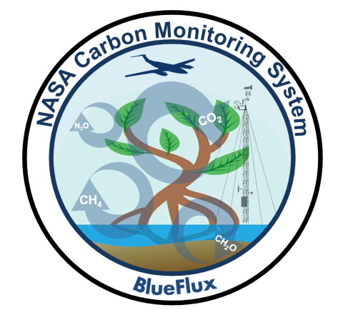
Blue Carbon Prototype Products for Mangrove Methane and Carbon Dioxide Fluxes (BLUEFLUX)
BLUEFLUX brings together scientists and engineers from the Earth Sciences Division at the NASA Goddard Space Flight Center, Yale University, Eastern Carolina University and Florida International University, to carry out measurements all the way from the individual mangrove leaf to an aircraft flying 300-feet overhead to instruments facing Earth from the International Space Station.

The Convective Processes Experiment – Aerosols & Winds (CPEX-AW)
The Convective Processes Experiment – Aerosols & Winds (CPEX-AW) campaign is a joint effort between the US National Aeronautics and Space Administration (NASA) and the European Space Agency (ESA) with the primary goal of conducting a post-launch calibration and validation activities of the Atmospheric Dynamics Mission-Aeolus (ADM-AEOLUS) Earth observation wind Lidar satellite in St. Croix. CPEX-AW is a follow-on to the Convective Processes Experiment (CPEX) field campaign which took place in the summer of 2017 (https://cpex.jpl.nasa.gov/). In addition to joint calibration/validation of ADM-AEOLUS, CPEX-AW will study the dynamics and microphysics related to the Saharan Air Layer, African Easterly Waves and Jets, Tropical Easterly Jet, and deep convection in the InterTropical Convergence Zone (ITCZ).
ACCLIP
The National Aeronautics and Space Administration (NASA) and the National Science Foundation's National Center for Atmospheric Research (NCAR) will conduct a jointly funded two-month campaign in Summer 2022* in the Republic of Korea: the Asian Summer Monsoon Chemical & CLimate Impact Project (ACCLIP). Two aircraft (the NASA WB-57 and the NCAR G-V), outfitted with state-of-the-art sensors, and approximately 80 scientists from the US and other international research organizations will participate in ACCLIP.

Student Airborne Science Activation (SaSa)
The Student Airborne Science Activation (SaSa) program invites highly motivated early-career undergraduates (first- and second-year students) at eligible universities to participate in an 8-week summer research experience. The full-time, paid internship includes a competitive stipend, housing, and travel. 25 participants will gain hands-on research experience in all components of a scientific research campaign, including flying onboard the NASA P-3 research aircraft to collect land, ocean, and atmospheric measurements.

High Ice Water Content (HIWC)
NASA researchers will be flying a DC-8 research plane, outfitted with state-of the-art radar and sophisticated meteorological probes to detect ice crystal icing conditions.
Aerosol Cloud Meteorology Interactions Over the Western Atlantic Experiment (ACTIVATE)
NASA’s Aerosol Cloud meTeorology Interactions oVer the western ATlantic Experiment (ACTIVATE) project is a five-year project (January 2019 – December 2023) that will provide important globally-relevant data about changes in marine boundary layer cloud systems, atmospheric aerosols and multiple feedbacks that warm or cool the climate. Marine boundary layer clouds play a critical role in Earth’s energy balance and water cycle.
ACTIVATE will study the atmosphere over the western North Atlantic Ocean and sample its broad range of aerosol, cloud and meteorological conditions using two aircraft based at NASA’s Langley Research Center. As an integral part of ACTIVATE, a suite of modeling tools and analysis techniques will be employed to inform preflight planning, perform data analysis, and climate model uncertainty quantification and improvement.
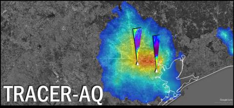
TRACER-AQ
In September 2021, NASA will deploy assets to the Houston, Texas region to measure air quality relevant constituents at high spatial and temporal resolutions. This effort will be conducted in partnership with the Texas Commission on Environmental Quality, the Department of Energy (DOE)-led Tracking Aerosol Convection interactions ExpeRiment (TRACER) campaign, and a number of academic collaborators. This synergistic deployment approach aims to address research questions under the umbrella of three focus areas:
1. Ozone Photochemistry and Meteorology
2. Modeling and Satellite Evaluation
3. Intersection of Air Quality and Socioeconomics Factors

Delta-X
The Delta-X mission seeks to answer this science question: What are the hydrological and ecological processes responsible for the resilience and vulnerability of river deltas to Relative Sea Level Rise (RSLR), and what are their relative contributions to soil elevation?
The mission’s objectives are to evaluate the roles of:
1. Vegetation on soil accretion rates
2. Channel-network density and deltaic island size on soil accretion rates
Oceans Melting Greenland (OMG)
Oceans Melting Greenland (OMG) is a NASA Mission led by JPL Scientist Josh Willis to understand the role that the ocean plays in melting Greenland’s glaciers. From the sky and the sea, OMG gathers data about water temperatures and the glaciers all the way around Greenland to get a better idea of just how fast the ice is melting, and how fast global sea levels will rise.
Global sea level rise will be one of the major environmental challenges of the 21st Century. Oceans Melting Greenland (OMG) will pave the way for improved estimates of sea level rise by addressing the question: To what extent are the oceans melting Greenland’s ice from below? Over a five-year campaign, OMG will observe changing water temperatures on the continental shelf surrounding Greenland, and how marine glaciers react to the presence of warm, salty Atlantic Water. The complicated geometry of the sea floor steers currents on the shelf and often determines whether Atlantic Water can reach into the long narrow fjords and interact with the coastal glaciers. Because knowledge of these pathways is a critical component of modeling the interaction between the oceans and ice sheet, OMG will facilitate improved measurements of the shape and depth of the sea floor in key regions as well.

DCOTSS
Dynamics and Chemistry of the Summer Stratosphere (DCOTSS) is a NASA Earth Venture Suborbital research project to investigate the impacts of intense thunderstorms over the U.S. on the summertime stratosphere.
For additional information on DCOTSS, including interviews, lesson plans, and activities, please visit this outreach page.
Operation IceBridge
IceBridge, a six-year NASA mission, is the largest airborne survey of Earth's polar ice ever flown. It will yield an unprecedented three-dimensional view of Arctic and Antarctic ice sheets, ice shelves and sea ice. These flights will provide a yearly, multi-instrument look at the behavior of the rapidly changing features of the Greenland and Antarctic ice.
Follow the Icebridge blog here:
http://blogs.nasa.gov/cm/blog/icebridge
and follow @NASA_ICE for mission tweets.

Cloud, Aerosol and Monsoon Processes Philippines Experiment (CAMP2Ex)
The Cloud, Aerosol and Monsoon Processes Philippines Experiment (CAMP2Ex) is a response to the need to deconvolute the fields of tropical meteorology and aerosol science at the meso-b to cloud level. The NASA Earth Science Division will be operating NASA’s P-3 (tail number N426NA) research aircraft and the SPEC, Inc. Lear Jet 35A (tail number N474KA) out of Clark Airport in the Philippines during the period 20 August to 10 October 2019. The scientific questions to be addressed by the Cloud and Aerosol Monsoonal Processes: Philippines Experiment (CAMP2Ex) are:
To what extent are aerosol particles responsible for modulating warm and mixed phase precipitation in tropical environments?
Aerosol and cloud microphysics: Examine how aerosol particle concentration and composition affect the optical and microphysical properties of shallow cumulous and congest clouds; and how, ultimately, these effects relate to the transition from shallower to deeper convection.
How does the aerosol and cloud influence on radiation co-vary and interact?
Cloud and Aerosol Radiation: Study how spatially inhomogeneous and changing aerosol and cloud fields impact three dimensional heating rates and fluxes, and determine the extent to which three dimensional effects may feedback into the evolution of the aerosol, cloud, and precipitation fields.
To what extent do aerosol induced changes in clouds and precipitation feedback into aerosol lifecycle? How does land use change affect cloud and precipitation change? Is land use change a confounder for aerosol impacts?
Aerosol and cloud meteorology: Determine the meteorological features that are the most influential in regulating the distribution of aerosol particles throughout the regional atmosphere and, ultimately, aerosol lifecycle, and ascertain the extent to which aerosol-cloud interactions studies are confounded and/or modulated by co-varying meteorology.
The research aircraft will be flown primarily over the ocean in the vicinity of the Philippines, including the ocean west of Luzon. The flights will include flying over, under and through convective cloud systems. In accord with NASA Earth Science data policy, the data and scientific results from this field campaign will be freely and openly available.

Fire Influence on Regional to Global Environments Experiment - Air Quality (FIREX-AQ)
Fire Influence on Regional to Global Environments and Air Quality (FIREX-AQ), a joint venture led by NOAA and NASA, provides comprehensive observations to investigate the impact on air quality and climate from wildfires and agricultural fires across the continental United States.

Atmospheric Carbon and Transport (ACT-America)
ACT-America, or Atmospheric Carbon and Transport – America, will conduct five airborne campaigns across three regions in the eastern United States to study the transport and fluxes of atmospheric carbon dioxide and methane. Each 6-week campaign will measure how weather systems transport these greenhouse gases. The objective of the study is to enable more accurate and precise estimates of the sources and sinks of these gases. Better estimates of greenhouse gas sources and sinks are needed for climate management and for prediction of future climate. ACT America addresses three primary sources of uncertainty in our ability to infer carbon dioxide and methane sources and sinks - transport error, prior flux uncertainty and limited data density.

ORACLES (ObseRvations of Aerosols above CLouds and their intEractionS)
Southern Africa produces almost a third of the Earth’s biomass burning (BB) aerosol particles, yet the fate of these particles and their influence on regional and global climate is poorly understood. ORACLES (ObseRvations of Aerosols above CLouds and their intEractionS) is a five year investigation with three Intensive Observation Periods (IOP) designed to study key processes that determine the climate impacts of African BB aerosols. Particles lofted into the mid-troposphere are transported westward over the SE Atlantic, home to one of the three permanent subtropical Stratocumulus (Sc) cloud decks in the world. The stratocumulus “climate radiators” are critical to the regional and global climate system. They interact with dense layers of BB aerosols that initially overlay the cloud deck, but later subside and are mixed into the clouds. These interactions include adjustments to aerosol-induced solar heating and microphysical effects. As emphasized in the latest IPCC report, the global representation of these aerosol-cloud interaction processes in climate models is the largest uncertainty in estimates of future climate.
The ORACLES experiment provides multi-year airborne observations over the complete vertical column of the key parameters that drive aerosol-cloud interactions in the SE Atlantic, an area with some of the largest inter-model differences in aerosol forcing assessments on the planet.

Long Island Sound Tropospheric Ozone Study (LISTOS)
The Long Island Sound Tropospheric Ozone Study (LISTOS) is a multi-agency collaborative study focusing on Long Island Sound and the surrounding coastlines that continue to suffer from poor air quality exacerbated by land/water circulations. The primary measurement operations are planned between June-September 2018 and include, but not limited to, in situ and remotely sensing instrumentation integrated aboard three aircrafts, a network of ground sites, mobile vehicle and boat measurements. The goal of this study is to improve the understanding of ozone chemistry and transport from New York City and upwind regions to downwind areas, particularly over Long Island Sound. Despite air quality improvements nationwide, the population in this region still suffers from high ozone concentrations year-to-year. The science team plans to work toward assessing emissions inventories over the region, as well as investigating the complicated chemistry and dynamic patterns associated with Long Island Sound and its coastlines influenced by sea breeze transported pollution.
This study extends on previous missions with similar research goals of increased understanding of poor air quality along coastlines influenced land/sea breeze interactions, including: DISCOVER-AQ over Chesapeake Bay (2011) and Gulf of Mexico/Galveston Bay (2013), LMOS in Western Lake Michigan (2017), and OWLETS over the lower (2017) and upper (2018) Chesapeake Bay.