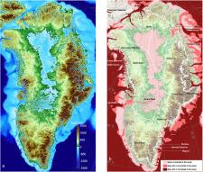
New maps of Greenland’s coastal seafloor and bedrock beneath its massive ice sheet show that two to four times as many coastal glaciers are at risk of accelerated melting as previously thought.
Researchers at the University of California at Irvine (UCI), NASA and 30 other institutions have published the most comprehensive, accurate and high-resolution relief maps ever made of Greenland's bedrock and coastal seafloor. Among the many data sources incorporated into the new maps are data from NASA's Ocean Melting Greenland (OMG) campaign.
Mission


