

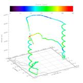
AJAX has recently begun a series of upwind/downwind ozone profile measurements intended to address the inflow of ozone during a variety of weather patterns and seasonal cycles. Vertical profiles of ozone over the San Joaquin Valley, coupled with upwind profiles over the Pacific Ocean, provide direct mapping of the vertical and horizontal ozone concentrations offshore and inland, to better understand trans-Pacific pollution transport and its effects on air quality in California.
In a second type of science flight, vertical profiles of greenhouse gases over Railroad Valley, NV, are collected in support of the Greenhouse gases Observing Satellite (GOSAT) total column measurements. AJAX provides calibrated, in-situ altitude-resolved vertical profiles of CO2 and CH4 from 25,000 ft down to the surface. These data are converted into a format comparable to satellite findings before being compared to the column measurements provided by GOSAT.
Regular vertical profiles of CO2 and CH4 continue to be collected over Railroad Valley, and the AJAX team is evaluating future collaborations with the JPL Atmospheric Infrared Sounder (AIRS) satellite team as well.
Ozone mixing ratios measured along a typical flight
track originating from NASA Ames Research Center.
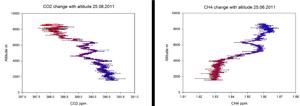
Carbon dioxide (left) and methane (right) mixing ratios measured
during descent over Railroad Valley, NV on 25 June 2011.