
News

NASA Selects New Aircraft-Driven Studies of Earth and Climate Change
NASA has selected six new airborne missions that include domestic and international studies of fire-induced clouds, Arctic coastal change, air quality, landslide hazards, shrinking glaciers, and emissions from agricultural lands. NASA’s suite of airborne missions complement what scientists can see from orbit, measure from the ground, and simulate in computer models.

Hazy Skies in a Growing City
Chiang Mai, the largest city in northern Thailand, is famed for having hundreds of Buddhist temples, some of which date to the city’s founding in the 13th century. This rich history—and easy access to hiking, waterfalls, and hot springs in the surrounding highlands, as well as being the setting of a hit movie in 2012—has turned the city into a hub of tourism that hosts as many as 10 million visitors per year.
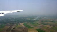
Grappling with Thailand’s Seasonal Haze
Each year in January and February, satellites begin to detect waves of smoke and fire in Southeast Asia, particularly in highland forests in Cambodia, Laos, Myanmar, and Thailand. Fire activity continues to increase through March and April, reaches a peak during the height of the dry season, and then fades in May with the start of the rainy season.
Individual fires are usually small and short-lived. But they are often so numerous that smoke, along with air pollution from rural and urban areas, mixes to produce thick layers of haze that blanket the landscape. Such hazes contain mixtures of small airborne particles called aerosols and gaseous pollutants such as nitrogen dioxide, sulfur dioxide, carbon monoxide, and ozone that degrade air quality and have harmful health effects.
In spring 2024, an international field campaign—ASIA-AQ (Airborne and Satellite Investigation of Asian Air Quality)—headed to Thailand to take a close look at the haze. During the last two weeks of March 2024, NASA’s DC-8 and Gulfstream III aircraft flew several flights over Chiang Mai, Bangkok, and rural areas surrounding the cities to sample air quality with several sensors. At the same time, satellites observed the haze from above.

A Tale of Three Pollutants
It was a hazy August day on Chicago’s South Side, and Nedra Sims Fears was hosting a small gathering to talk about the air. Interstate-94, which bisects her Chatham neighborhood, hummed nearby. “This was the summer I spent watching summer out my window,” Fears said.
That’s because asthma runs in her family, and smoke from wildfires in Canada had wafted into Chicago, making it difficult for her to breathe. Many of her neighbors don’t have air conditioning, which means they don’t have the luxury of shutting their windows against the tiny hazardous particles contained in the smoke.
Several thousand feet above the Fears’ home, one of the largest flying laboratories in the world circled the skies over Chicago. The plane – NASA’s four-engine DC-8 jet – is a storied research craft. Over the past 25 years it has supported field campaigns across all seven continents. On this August 2023 day, it carried 40 researchers and a pack of scientific instruments investigating air pollution over the cities and pasturelands of the Midwest.

NASA Ames’ Contributions to OSIRIS-REx
NASA’s Langley Research Center in Hampton, Virginia, will manage an experiment taking advantage of the OSIRIS-REx sample arrival to study characteristics of re-entry through an atmosphere. Four aircraft and teams at three ground sites will track the capsule’s trajectory on its way to the surface, using imaging and spectroscopy instruments. Data from the project, called Hypervelocity OSIRIS-REx Reentry Imaging & Spectroscopy (HORIS), will be used to validate and develop planetary entry models. NASA’s Earth Science Project Office (ESPO), based at Ames, will provide operational and shipping support to two international ground teams by setting up work sites at three different locations in northern Nevada.

Surf, Turf, Above Earth: Students Participate in NASA Field Research
Flying over and tromping through watery landscapes along the East Coast, working alongside NASA scientists, and recording measurements about the air that they’re travelling through – these are not the usual experiences for an undergraduate student. For the 2023 participants in NASA’s SARP East program – short for Student Airborne Research Program – it was part of a summer they won't forget.

NASA Student Airborne Research Program 2023: Sky-High Science Learning
NASA’s Armstrong Flight Research Center hosted undergraduate students for the 2023 Student Airborne Research Program. An eight-week summer internship program, SARP offers upper-level undergraduate students the opportunity to acquire hands-on research experience as part of a real scientific campaign. This year SARP, the Student Airborne Research Program, celebrated 15 years of success in the Airborne Science Program. Students worked alongside scientists and aircraft professionals both on the ground and in the sky, using NASA Airborne Science Program’s flying science laboratories, like NASA Armstrong’s DC-8 aircraft. Outfitted specifically for science research projects, aircraft like the DC-8 help support both students and mission personnel to investigate science questions, aid in the understanding of our environment, and improve life on Earth.
Learn more about SARP: https://baeri.org/sarp/
 and Terrestrial gamma-ray flashes (ALOFT) field campaign takes a break in front of NASA Armstrong’s ER-2 aircraft following its safe return from a mission on July 24. The ALOFT field campaign spent 30 days studying gamma-ray glows and flashes produced from the electric fields of thunderclouds. Credits: NASA")
Global Collaboration Leads to New Discoveries in Lightning Research
With operations based out of Tampa, Florida, the ALOFT field campaign logged approximately 60 hours of flight time across Central America and the Caribbean. The team used NASA Armstrong’s ER-2 aircraft to fly near thunderclouds as tall as 18 kilometers (10 miles) in altitude in order to measure gamma-ray glows and flashes produced by the electric fields of thunderclouds. ALOFT is short for Airborne Lightning Observatory for Fly’s Eye GLM Simulator and Terrestrial gamma-ray flashes. The campaign included researchers and flight crews from the University of Bergen, NRL, NASA’s Armstrong Flight Research Center, NASA’s Marshall Space Flight Center, and NASA’s Goddard Space Flight Center.

NASA’s ER-2 Aircraft Flies High to Investigate Lightning
In July 2023, NASA’s ER-2 aircraft has been flying close to thunderclouds to investigate lightning and its connection to the vast energy fields in our atmosphere. As the highest-flying plane of NASA’s Airborne Science Program, the ER-2 is giving researchers a new angle on storm clouds.

NASA Pilots Get Dunked
What’s it like to escape from an aircraft underwater? NASA research pilots Wayne Ringelberg, and Scott Howe recently found out when they completed pilot dunker training at the FAA (Federal Aviation Administration) Mike Monroney Aeronautical Center Civil Aerospace Medical Institute in Oklahoma. This training certifies the pilots to fly helicopters over bodies of water for upcoming automated systems flight testing for NASA’s Advanced Air Mobility research with Sikorsky and DARPA (Defense Advanced Research Project Agency).

Elation Through Filtration: An Oceanographer’s Sensations at Sea
Being a biological oceanographer on a physical oceanographic voyage has highlighted a key distinction between the two disciplines. Physical oceanographers rely on sensing – deploying instrumentation that measures properties of the water: temperature, velocity, oxygen, etc. Those data are sent back to laptops allowing for near instantaneous analysis. The day-to-day work of biological oceanography, on the other hand, may be a science best described by filtering – a task that is intertwined with most measurements in our field. We collect water and remove the particles or organisms we want to study. The finest filter might have holes that let only the tiniest particles through, while the largest filter could be something like a large net, where even fish can slip through its mesh.
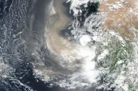
In Dust and Clouds Over Africa, Scientists Find Clues to How Hurricanes Form
When the dust that wafts off the Sahel and Sahara regions of Africa mixes with tropical clouds, it creates what’s known as a rainy “disturbance” in the eastern Atlantic. These disturbances are hurricanes in their youngest form, and as they travel across the ocean, they can either dissipate or grow into powerful storms.
To study these infant storms, a group of NASA scientists in September 2022 spent a month flying off the northwestern coast of Africa aboard NASA’s DC-8 research plane. Each day, the team took off from Cabo Verde, an island nation off the west coast of Africa, logging roughly 100 hours altogether. The mission, known as the Convective Processes Experiment – Cabo Verde (CPEX-CV) released its data publicly on April 1.
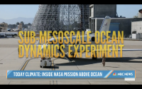
A look at NASA’s new mission to explore the Earth’s oceans
Scientists at NASA are on a mission to study the surface of the Earth's oceans to observe how eddies, whirlpools and currents interact with the atmosphere and shape the Earth’s climate. NBC’s Jacob Soboroff reports for TODAY.
 mission. Image Credit: NASA/Avery Snyder")
On the Edge: NASA’s Last S-MODE Mission Studies the Ocean’s Surface
NASA has taken to the seas and skies to study the unique environment at the ocean’s surface, where marine ecosystems intersect with our planet's complex atmosphere. On April 7, 2023, scientists participating in the Sub-Mesoscale Ocean Dynamics Experiment (S-MODE) embarked on the RV Sally Ride from San Diego on the last of three field expeditions to understand the ocean’s role in the Earth’s changing climate. They will be at sea for about a month until returning to San Diego on May 4, and they will operate for most of that period in tandem with an accompanying airborne campaign.

Dr. Brenna Biggs Presents “Wave” Hello to NASA S-MODE: A Study of Sub-Mesoscale Ocean Processes
Dr. Brenna Biggs hosted a panel of S-MODE scientists at an Earth Day event at the Chabot Space and Science Center for K-12 students on April 22, 2023.
, director of the Earth Sciences Division at NASA’s Ames Research Center, describes to U.S. Rep. Anna Eshoo the use of autonomous uncrewed aircraft to carry cameras and sensors for monitoring of environmental events such as wildfires or volcanic activity. Credits: NASA/Dominic Hart")
NASA Leaders View Climate Science, Wildfire Innovations at NASA Ames
NASA is working to understand climate change and build resilience to its risks, such as the increasing threat of wildfire, for the nation and the world. On April 13, the agency’s top leadership visited NASA’s Ames Research Center in California’s Silicon Valley to learn about the center’s climate science and innovations in aeronautics that will help people everywhere face these challenges.

Scientists are flying into snowstorms to explore winter weather mysteries
High up in some ice-filled clouds, sitting inside an airplane loaded with science instruments, Christian Nairy looked at pictures flashing on his computer screen. This high-altitude slideshow is displaying real-time images of cloud particles being sampled by a device out on the plane's wing — and some of the ice crystals looked like perfect little snowflakes.

NASA Armstrong Showcases Women in Aviation
NASA’s Armstrong Flight Research Center has a long history with employing women in aviation careers and empowering these women to reach for the sky, although it was not always this way. Today, several of the key NASA aeronautics projects are led by females.

BioSCape ARSET Webinar - Biodiversity Applications for Airborne Imaging Systems
We are thrilled to announce that registration for NASA's Applied Remote Sensing Training Program (ARSET) is now live! This course is designed to help prepare the community to use BioSCape's airborne data sets. The course is called "Biodiversity Applications for Airborne Imaging Systems" and is a webinar run over four sessions between 27th March and 5th April. Please register through the link above.

A Nervous Flier’s Guide to Riding the Snowy Skies
I grew up flying in planes. I’m comfortable in them. But there’s one part of flying I’ve never gotten used to: turbulence. It’s common on commercial flights, so over the years I’ve learned a few tips and tricks on how to stay calm when my mind seems to take off at a sprint.
.")
How a Cold War spy plane went from watching the Soviets to watching the weather for NASA
Located just north of Atlanta, Georgia, Dobbins Air Reserve Base is usually home to C-130 transport planes. But for the next few weeks, the base will host an unusual guest: a white-painted jet that can fly for more than half a day at the edge of space.

NASA’s C-20A deploys to Hawaii Following Volcanic Eruption
Following the eruption of the world’s largest active volcano, Mauna Loa, NASA Armstrong Flight Research Center deployed its C-20A aircraft to Kona, Hawaii, to gather images and data of the active lava flows for submission to the United States Geological Survey (USGS) by a team of scientists at NASA’s Jet Propulsion Laboratory (JPL).

Cloudy with a Chance for Whirlpools: Ocean Models Guide NASA’s S-MODE Mission
NASA’s S-MODE mission faces quite the challenge: robustly observe, for the first time, ocean features spanning up to about 6.2 miles (10 kilometers) across. Currently, the oceanographic community routinely observes and studies very large ocean features, primarily through space-based instrumentation. These include strong currents such as the Gulf Stream that runs from Florida along the East Coast of the United States all the way to western Europe. Large vortexes are also observed – these being the cyclones and anticyclones you may have seen on your evening weather forecasts.

Where No Map Leads: Reflections from NASA’s S-MODE Mission
It’s like stumbling through a thick forest and breaking out into a glade. A quiet has settled on this piece of sea as the waves calm. You can’t make a good map to get to this place. In the ocean, these glades are always moving, twisting, being born into life by the collision of great currents, then breaking apart, fracturing and sinking beneath the waves. The cold water brought from below by the coastal winds creates a fog that lies heavy on the sea surface, creating this small, calm spot.
Places like this can be found by things with nowhere else to go. Throw something off the side of a boat and it will likely end up somewhere like here. We’re at a convergence zone that attracts floating debris of all sizes. In particular, it attracts minuscule plankton, along with all the things that eat them and all the things that eat those things and so on and so on. All of it dragged hereby the undulating ocean.

Finding Nature at Sea During NASA’s S-MODE Field Campaign
My favorite part of being at sea is the opportunity to see unique parts of the natural world that aren’t accessible from land. My colleagues have done a fantastic job in their blog posts explaining the science that we’ve been conducting during S-MODE, so I want to take this opportunity to describe some of the sights that those of us on the Bold Horizon have been able to enjoy during our field work: birds, mammals, weather, and stars.
 and Avery Snyder (right) getting ready to deploy a mixed layer float. Credit: Alex Kinsella")
A First Cruise Experience with NASA’s S-MODE Field Campaign
I had been patiently waiting and dreaming about this research cruise for months. Yet a few days before traveling from Connecticut to Oregon for ship mobilization, I couldn’t shake a feeling of denial – like I couldn’t believe I was really going to be out in the Pacific Ocean on a research vessel for an entire month.
I am participating in NASA’s Sub-Mesoscale Ocean Dynamics Experiment (S-MODE) as part of the science party aboard the research vessel Bold Horizon. The focus of this experiment is to sample ocean fronts that are a few miles in size to study their dynamics and effects on vertical transport. The ocean fronts are sampled using aircraft, ship surveying, and autonomous platforms with names such as wave gliders, sea gliders, Saildrones, floats, and drifters. So being aboard the ship is just one piece of this complex research experiment.

Life at Sea: A “First-Timer” Chronicles NASA’s S-MODE Field Campaign
Going to sea for the first time as part of NASA’s S-MODE mission has been an experience like no other. You establish a new normal on the boat and quickly fall into new routines. Perceptions of time even change! I joked with some people on the boat that time is but a label on our samples. Perhaps that’s a bit dramatic, but normal perceptions of time do not apply at sea –especially if you start your day at 2 pm and finish at 2 am.
. Credit: Erin Czech.")
Student of the Sea: Learning the Ropes Aboard NASA’s S-MODE Mission
NASA’s S-MODE mission was designed to measure and understand the complex oceanic features classified as “submesoscale,” i.e., features spanning up to 6.2 miles (10 kilometers) across. Such fine filaments and sharp density fronts in the ocean are responsible for fast and unpredictable changes in velocity, temperature, salinity, and even among small organisms called plankton in the surface layer of the ocean. A myriad of autonomous instruments, airborne sensors, and a fully equipped ship are part of the robust methods of measuring submesoscale dynamics in the California Current region.
 in the Pacific Ocean off the U.S. West Coast. Credits: Ben Hodges / Woods Hole Oceanographic Institution (WHOI)")
NASA’s S-MODE Field Campaign Deploys to the Pacific Ocean
When the research vessel Bold Horizon sailed from Newport, Oregon, in early October, it joined a small armada of planes, drones, and other high-tech craft chasing the ocean’s shapeshifting physics. NASA’s Sub-Mesoscale Ocean Dynamics Experiment (S-MODE) is converging on a patch of sea 110 nautical miles off the coast of San Francisco. Over the course of 28 days, the team will deploy a new generation of tools to observe whirlpools, currents, and other dynamics at the air-sea boundary. The goal: to understand how these dynamics drive the give-and-take of nutrients and energy between the ocean and atmosphere and, ultimately, help shape Earth’s climate.

Alaska’s Newest Lakes Are Belching Methane
“This lake wasn’t here 50 years ago.” Katey Walter Anthony, an ecologist at the University of Alaska-Fairbanks, dips her paddle into the water as her kayak glides across the lake. “Years ago, the ground was about three meters taller and it was a spruce forest,” she says. Big Trail Lake is a thermokarst lake, which means it formed due to permafrost thaw. Permafrost is ground that stays frozen year round; the permafrost in interior Alaska also has massive wedges of actual ice locked within the frozen ground. When that ice melts, the ground surface collapses and forms a sinkhole that can fill with water. Thus, a thermokarst lake is born.