

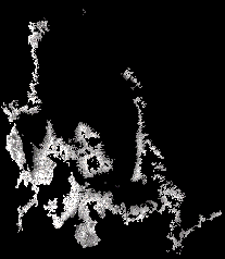
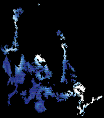
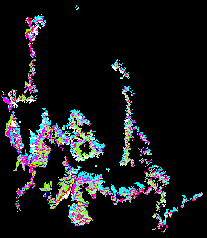
The field sampling strategy was designed to capture the greatest possible range of environmental conditions. The vegetation map for the Walker River Basin was intersected with other environmental datasets in a geographic information system. The selected GIS datasets were selected based on their expected relevance to populations of deer mice (e.g. distance from streams used in desert areas, but not in wetlands). Figures 1 and 2 below display the variability in Landsat-derived NDVI (vegetation productivity) and distance from streams within areas that were mapped as sage brush scrub. Each of these GIS datasets were then split into binary strata of above versus below average values within each vegetation class. By intesecting all of these individual strata within each vegetation class, we could ensure thorough representation of environmental variability within each habitat type (figure 3). Field sampling sites were then randomly located in each of these intersected strata.
|
|
|
| Figure 1 | Figure 2 | Figure 3 |
 Back to the
CHAART Hantavirus First Year Report
page
Back to the
CHAART Hantavirus First Year Report
page